School nearby المتوسطة 169
Saudi Arabia
School nearby المتوسطة 169
المتوسطة 169
Riyadh Saudi Arabia
contacts phone
:
+966
Latitude:
24.591472
, Longitude:
46.69478
read more
nearest School
67 m
مدرسة شوشو
6711, Riyadh
School
read more
68 m
المدرسة الابتدائية 254
6629 Jamil Al Ali, Riyadh
School
read more
99 m
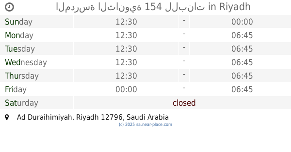
المدرسة الثانوية 154 للبنات
Riyadh
School
read more
493 m
Shubra Primary School
Abdul Rahman Ibn Dinar, Riyadh
School
read more
588 m
متوسطة سفيان ابن عيينة
Riyadh
School
read more
597 m
مدرسة سفيان بن عيينة
Riyadh
School
read more
638 m
مدرسة الوليد بن عبدالملك الإبتدائية
Riyadh
School
read more
655 m
مدرسة تعليم قيادة المرور غرب الرياض
Riyadh
School
read more
738 m
معهد التربيه الفكريه بنات
7295, Riyadh
School
read more
738 m
مدرسة 154 الإبتدائية
Riyadh
School
read more
746 m
Institute of Intellectual Education - West - Girls
2711 As Suwaidi Al Am, Riyadh
School
read more
752 m
مدرسة عتبة بن غزوان الإبتدائية
Al Abbas Ibn Ghalib, Riyadh
School
read more
770 m
مدارس القمم الأهلية
الحديقة Al Hadeeqa, Riyadh
School
read more
785 m
مدارس القمم الأهلية
2207 As Suwaidi Al Am, Riyadh
School
read more
791 m
مدارس جيل الاصالة
Sadir, Riyadh
School
read more
795 m
شركة مدارس رياض العلوم
Tamim Ad Dari, Riyadh
School
read more
803 m
Riyadh Ul Uloom School
4962 Tamim Ad Dari, Shubra, Riyadh 12797 8065 Tamim Ad Dari, Riyadh
School
read more
823 m
اكاديمية الاشبال لكرة القدم
Riyadh
School
read more
838 m
مدارس التقوى الأهلية
Riyadh
School
read more
849 m
Elementary School ninth
4640 Al Munajji, Riyadh
School
read more
863 m
Sixty-six middle school
Southern Ring Road, Riyadh
School
read more
905 m
School
الإبتدائية المائة وثلاثة وخمسون، جلال اباد،, Riyadh
School
read more
905 m
School-Exit 24
الإبتدائية المائة وثلاثة وخمسون، جلال اباد،, Riyadh
School
read more
995 m
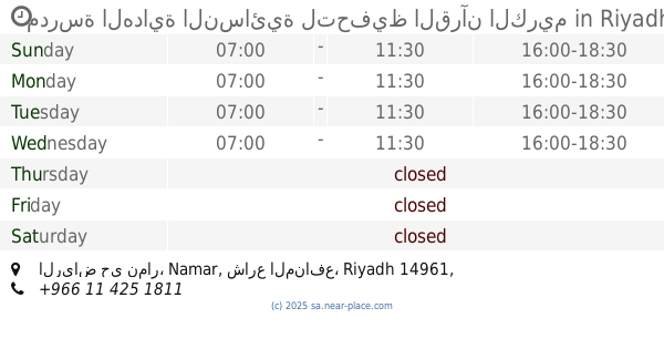
مدرسة الهداية النسائية لتحفيظ القرآن الكريم
الرياض حي نمار, شارع المنافع, Riyadh
School
read more
1.055 km
Medina Elementary School
Adma, Riyadh
School
read more
📑
all categories
Accounting
Administrative area level 1
Airport
Amusement park
Aquarium
Art gallery
Atm
Bakery
Bank
Bar
Beauty salon
Bicycle store
Book store
Bowling alley
Bus station
Cafe
Campground
Car dealer
Car rental
Car repair
Car wash
Casino
Cemetery
Church
City hall
Clothing store
Colloquial area
Convenience store
Country
Courthouse
Dentist
Department store
Doctor
Electrician
Electronics store
Embassy
Finance
Fire station
Florist
Food
Funeral home
Furniture store
Gas station
General contractor
Grocery or supermarket
Gym
Hair care
Hardware store
Health
Hindu Temple
Home goods store
Hospital
Insurance agency
Intersection
Jewelry store
Laundry
Lawyer
Library
Light rail station
Liquor store
Local government office
Locality
Locksmith
Lodging
Meal delivery
Meal takeaway
Mosque
Movie rental
Movie theater
Moving company
Museum
Natural feature
Neighborhood
Night club
Painter
Park
Parking
Pet store
Pharmacy
Physiotherapist
Place of worship
Plumber
Point of interest
Police
Political
Post office
Premise
Real estate agency
Restaurant
Roofing contractor
Route
Rv park, camping
School
Shoe store
Shopping mall
Spa
Stadium
Storage
Store
Sublocality
Subpremise
Subway station
Supermarket
Taxi stand
Train station
Transit station
Travel agency
University
Veterinary care
Zoo
sublocality level 1
↑