School nearby الروضة السادسة عشر
Saudi Arabia
School nearby الروضة السادسة عشر
الروضة السادسة عشر
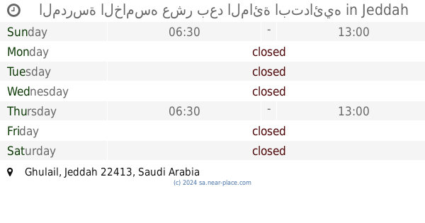
4757, Ibn Al Hamamah, 22413, Jeddah, SA Saudi Arabia
contacts phone
:
+966 12 636 1175
Latitude:
21.4504745
, Longitude:
39.2055829
larger map & directions
read more
nearest School
79 m
Rizzi School dualism
4746 ابن الحمامه، حي غليل، جدة 22413 7965 Ibn Al Hamamah, Jeddah
School
read more
138 m
المدرسة التاسعة الثانوية
Jeddah
School
read more
159 m
مركز الحي المتعلم الرابع بجدة بنين
4793 حسن حسنين، حي غليل جدة 22413 جدة غليل
School
read more
169 m
مركز الحي المتعلم الرابع بجدة
جدة
School
read more
174 m
مدرسة عروة بن مسعود الابتدائية
جدة
School
read more
181 m
Ayaz Bin Zuhair Middle School old building
Khulayd Al Hadari, Jeddah
School
read more
197 m
الابتدائية 53
4652 Muhammad Harasani, حي غليل،, Jeddah
School
read more
204 m
الابتدائية الثالثه والخمسون
4652 Muhammad Harasani, حي غليل،, Jeddah
School
read more
207 m
المدرسة الثانية والخمسون ابتدائية
Jeddah
School
read more
207 m
المدرسة الخامسه عشر بعد المائة ابتدائيه
Jeddah
School
read more
207 m
مدارس ابتدائبه اولاد
Jeddah
School
read more
207 m
مدرسة التاسعة والثلاثون الثانوية بجدة
Jeddah
School
read more
207 m
St Hassan
Jeddah
School
read more
271 m
School First Forty Girls
4925 Zaynal, Jeddah
School
read more
275 m
Forty One primary school for girls
Zaynal, Jeddah
School
read more
283 m
المدرسة العاشرة المتوسطة للبنات
Ibn Judi, Jeddah
School
read more
301 m
المتوسط الرابعة و الأربعون
4553 Muhammad Harasani, Jeddah
School
read more
395 m
Razi High School
المصفاة جدة
School
read more
397 m
Ayaz Bin Zuhair School
Khulayd Al Hadari, Jeddah
School
read more
415 m
Razi Middle School
Qathim Ibn Abbas, Jeddah
School
read more
417 m
معهد العلم الثالث
4681 ابن الازرق،، جدة
School
read more
424 m
Um Al-Fadl
Jeddah
School
read more
434 m
Saad bin Abi Waqas Primary School
Ibn Shalabi, Jeddah
School
read more
458 m
iibn sina national college for medical
Jeddah
School
read more
480 m
School 102 Elementary School
طريق غليل, Jeddah
School
read more
📑
all categories
Accounting
Administrative area level 1
Airport
Amusement park
Aquarium
Art gallery
Atm
Bakery
Bank
Bar
Beauty salon
Bicycle store
Book store
Bowling alley
Bus station
Cafe
Campground
Car dealer
Car rental
Car repair
Car wash
Casino
Cemetery
Church
City hall
Clothing store
Colloquial area
Convenience store
Country
Courthouse
Dentist
Department store
Doctor
Electrician
Electronics store
Embassy
Finance
Fire station
Florist
Food
Funeral home
Furniture store
Gas station
General contractor
Grocery or supermarket
Gym
Hair care
Hardware store
Health
Hindu Temple
Home goods store
Hospital
Insurance agency
Intersection
Jewelry store
Laundry
Lawyer
Library
Light rail station
Liquor store
Local government office
Locality
Locksmith
Lodging
Meal delivery
Meal takeaway
Mosque
Movie rental
Movie theater
Moving company
Museum
Natural feature
Neighborhood
Night club
Painter
Park
Parking
Pet store
Pharmacy
Physiotherapist
Place of worship
Plumber
Point of interest
Police
Political
Post office
Premise
Real estate agency
Restaurant
Roofing contractor
Route
Rv park, camping
School
Shoe store
Shopping mall
Spa
Stadium
Storage
Store
Sublocality
Subpremise
Subway station
Supermarket
Taxi stand
Train station
Transit station
Travel agency
University
Veterinary care
Zoo
sublocality level 1
↑