School nearby الثانوية الاولى بالخويلدية
Saudi Arabia
School nearby الثانوية الاولى بالخويلدية
الثانوية الاولى بالخويلدية
شارع, Jeddah Saudi Arabien
contacts phone
:
+966
Latitude:
26.5496992
, Longitude:
49.9876173
read more
nearest School
131 m
شقة السيد نور
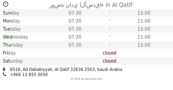
6426, Al Qatif
School
read more
421 m
Alkhuyldeh High School
2933, Al Qatif
School
read more
438 m
Alkhuyldeh elementary and middle school
Al Qatif
School
read more
576 m
مدرسة البنات بالخويلدية
2685, Al Qatif
School
read more
923 m
المدرسة السابعة الإبتدائية للبنات
Al Qatif
School
read more
956 m
Ahnaf ibn Qais Elementary School Baltobi
7151, Al Qatif
School
read more
970 m
المدرسة الإبتدائية الثانية بالتوبي
6869, 3337, Al Qatif
School
read more
1.071 km
Al Jaroodiah Primary School
Al Qatif
School
read more
1.077 km
حسينية الامام الحسن عليه السلام
Unnamed Road, Al Qatif
School
read more
1.081 km
مدرسة القبلتين الثانوية
3483, Al Qatif
School
read more
1.124 km
مدرسة زيد بن أرقم المتوسطة
Al Qatif
School
read more
1.128 km
مدرسة زيد بن
6912, 3490, Al Qatif
School
read more
1.172 km
دار الحسين
Al Qatif
School
read more
1.204 km
مدرسه الثانوية الاولى بالتوبي
Al Qatif
School
read more
1.207 km
مدرسة الثانوية الاولى بالتوبي للبنات
6709 الملك فيصل بن عبد العزيز, Al Qatif
School
read more
1.253 km
Jaroudia Intermediate School
Al Qatif
School
read more
1.26 km
little stars
Al Qatif
School
read more
1.453 km
روضة نادي الأصدقاء
6516, Al Qatif
School
read more
1.47 km
مدرسة المتوسطة والثانوية للبنات بحلة محيش
3309، Al، Qatif، 32652
School
read more
1.472 km
متوسطة وثانوية حلة محيش الجمال والإبداع
Al Qatif
School
read more
1.474 km
مدرسة التوبي الابتدائية ( بنين )
7244، المنطقة المركزية، القطيف 32636
School
read more
1.477 km
مدرسة زيد بن الارقم المتوسطة - مدرسة القبلتين الثانوية
القطيف
School
read more
1.497 km
مدرسة حلة محيش الابتدائية للبنات
3349, Al Qatif
School
read more
1.5 km
الابتدائية الحادية عشر بالقطيف
6333 الملك فيصل بن عبد العزيز، المسعودية القطيف 32636
School
read more
1.508 km
Falah Primary School Qatif
القطيف
School
read more
📑
all categories
Accounting
Administrative area level 1
Airport
Amusement park
Aquarium
Art gallery
Atm
Bakery
Bank
Bar
Beauty salon
Bicycle store
Book store
Bowling alley
Bus station
Cafe
Campground
Car dealer
Car rental
Car repair
Car wash
Casino
Cemetery
Church
City hall
Clothing store
Colloquial area
Convenience store
Country
Courthouse
Dentist
Department store
Doctor
Electrician
Electronics store
Embassy
Finance
Fire station
Florist
Food
Funeral home
Furniture store
Gas station
General contractor
Grocery or supermarket
Gym
Hair care
Hardware store
Health
Hindu Temple
Home goods store
Hospital
Insurance agency
Intersection
Jewelry store
Laundry
Lawyer
Library
Light rail station
Liquor store
Local government office
Locality
Locksmith
Lodging
Meal delivery
Meal takeaway
Mosque
Movie rental
Movie theater
Moving company
Museum
Natural feature
Neighborhood
Night club
Painter
Park
Parking
Pet store
Pharmacy
Physiotherapist
Place of worship
Plumber
Point of interest
Police
Political
Post office
Premise
Real estate agency
Restaurant
Roofing contractor
Route
Rv park, camping
School
Shoe store
Shopping mall
Spa
Stadium
Storage
Store
Sublocality
Subpremise
Subway station
Supermarket
Taxi stand
Train station
Transit station
Travel agency
University
Veterinary care
Zoo
sublocality level 1
↑