School nearby التشغيل والصيانة حائل
Saudi Arabia
School nearby التشغيل والصيانة حائل
التشغيل والصيانة حائل
Al Mahattah, Hail Saudi Arabia
contacts phone
:
+966 16 531 0900
Latitude:
27.5143436
, Longitude:
41.6911096
larger map & directions
read more
nearest School
57 m
Office of Education in South Hail
Muaz Ibn Jabal, Hail
School
read more
130 m
نادي الحاسب الآلي بحائل
5407 معاذ بن جبل -رضي الله عنه-، المحطة، حائل 55424
School
read more
152 m
الجزيرة الابتدائية
Hail
School
read more
165 m
متوسطة الإمام محمد بن سعود
Ad Dammam, Hail
School
read more
391 m
محلل إحصائي
Al-Imam Muhammad Ibn Saud, Hail
School
read more
407 m
حضانة صلاتى
4211, 9401, Hail
School
read more
415 m
Elementary 27 Hail Girls
27 Saudi Arabia, 5119907, Parañaque
School
read more
423 m
الروضة الخامسة عشر
حائل
School
read more
440 m
King Fahd Mosque rings Center
5727, Hail
School
read more
453 m
الثانوية الثانية
9453, Hail
School
read more
512 m
HTA Offices, University of Hail
5266, Hail
School
read more
530 m
المتوسطة الرابعة عشر بنات
الفرات, Hail
School
read more
534 m
General Directorate of Education
6834 King Abdulaziz Road, Hail
School
read more
545 m
المتوسطة التاسعه عشر للبنات بحائل
4969, Hail
School
read more
566 m
الابتدائية الثالثة والعشرون بنات
4673 جانين, Hail
School
read more
580 m
27 elementary school girls
3961, Hail
School
read more
582 m
ابتدائية السابعة والعشرون بنات
3961, 9448, Hail
School
read more
587 m
Secondary eighth Girls
9547, Hail
School
read more
627 m
Hael University
5421, Hail
School
read more
657 m
عملدة خدمة المجتمع
5421, Hail
School
read more
659 m
خدمة وعمادة التعليم المتجمع المتستمر المبنى الرئيسي
5421, Hail
School
read more
671 m
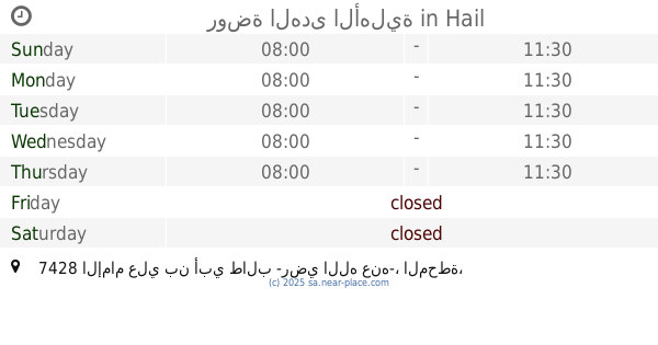
روضة الهدى الأهلية
7428 الإمام علي بن أبي طالب -رضي الله عنه-، المحطة، حائل 55424
School
read more
699 m
ابتدائية الأندلس
Hail
School
read more
716 m
Medium Umm Al Qura
3883 Al-Imam Muhammad Ibn Saud, 9276،, Hail
School
read more
802 m
Rabua Al Hekma
7005 Al Amir Sultan Ibn Abdul Aziz, Al Mahattah, Hail 55424 4509 Al Amir Sultan Ibn Abdul Aziz, Hail
School
read more
📑
all categories
Accounting
Administrative area level 1
Airport
Amusement park
Aquarium
Art gallery
Atm
Bakery
Bank
Bar
Beauty salon
Bicycle store
Book store
Bowling alley
Bus station
Cafe
Campground
Car dealer
Car rental
Car repair
Car wash
Casino
Cemetery
Church
City hall
Clothing store
Colloquial area
Convenience store
Country
Courthouse
Dentist
Department store
Doctor
Electrician
Electronics store
Embassy
Finance
Fire station
Florist
Food
Funeral home
Furniture store
Gas station
General contractor
Grocery or supermarket
Gym
Hair care
Hardware store
Health
Hindu Temple
Home goods store
Hospital
Insurance agency
Intersection
Jewelry store
Laundry
Lawyer
Library
Light rail station
Liquor store
Local government office
Locality
Locksmith
Lodging
Meal delivery
Meal takeaway
Mosque
Movie rental
Movie theater
Moving company
Museum
Natural feature
Neighborhood
Night club
Painter
Park
Parking
Pet store
Pharmacy
Physiotherapist
Place of worship
Plumber
Point of interest
Police
Political
Post office
Premise
Real estate agency
Restaurant
Roofing contractor
Route
Rv park, camping
School
Shoe store
Shopping mall
Spa
Stadium
Storage
Store
Sublocality
Subpremise
Subway station
Supermarket
Taxi stand
Train station
Transit station
Travel agency
University
Veterinary care
Zoo
sublocality level 1
↑