School nearby Dhahran Daycare Center
Saudi Arabia
School nearby Dhahran Daycare Center
Dhahran Daycare Center
Dhahran Saudi Arabia
contacts phone
:
+966
Latitude:
26.3100892
, Longitude:
50.1235124
read more
nearest School
464 m
B-2050 Computer training center
3383, Dhahran
School
read more
486 m
Staff Development, building 2050
Dhahran
School
read more
909 m
Gl. Cb k kabf
1118 Ibis Avenue, Dhahran
School
read more
932 m
Qv
B Street, Dhahran
School
read more
1.524 km
Summer A "Aramco"
Dhahran
School
read more
1.525 km
Saudi Aramco Expatriate Schools
Dhahran
School
read more
1.568 km
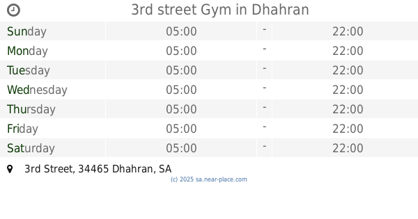
3rd street Gym
3rd Street, Dhahran
School
read more
1.572 km
Dhahran School
7467, Dhahran
School
read more
1.634 km
Building 228
Dhahran
School
read more
1.77 km
Building 63
3777, 6828, Dhahran
School
read more
1.865 km
Chemical Engineering Department - Building 16 قسم الهندسة الكيميائية
3862, Dhahran
School
read more
1.931 km
University Home
3923 King Fahd University of Petroleum and Minerals Dhahran 34463
School
read more
1.964 km
College Of Applied And Supporting Studies
3916, Dhahran
School
read more
1.981 km
Architecture and Architecture Engineering Department-Building 18
Building 18 Access Road, Dhahran
School
read more
1.984 km
Building 829
Dhahran
School
read more
2.019 km
Building 7
3995, Dhahran
School
read more
2.098 km
PELP Building 9133
8306 Munirah Road, Dhahran
School
read more
2.1 km
PELC
Dhahran
School
read more
2.208 km
DH Work
North Park Road, Dhahran
School
read more
2.273 km
ANH
8669, Dhahran
School
read more
2.307 km
ايتيسي
Dhahran
School
read more
2.391 km
اختبار القدرات جامعة البترول
Dhahran
School
read more
2.398 km
Elite KFUPM Toastmasters club
4306, Dhahran
School
read more
2.547 km
Al Fozan Academy
Old Admin Road, Dhahran
School
read more
2.57 km
أكاديمية الفوزان Alfozan Academy
6847, Dhahran
School
read more
📑
all categories
Accounting
Administrative area level 1
Airport
Amusement park
Aquarium
Art gallery
Atm
Bakery
Bank
Bar
Beauty salon
Bicycle store
Book store
Bowling alley
Bus station
Cafe
Campground
Car dealer
Car rental
Car repair
Car wash
Casino
Cemetery
Church
City hall
Clothing store
Colloquial area
Convenience store
Country
Courthouse
Dentist
Department store
Doctor
Electrician
Electronics store
Embassy
Finance
Fire station
Florist
Food
Funeral home
Furniture store
Gas station
General contractor
Grocery or supermarket
Gym
Hair care
Hardware store
Health
Hindu Temple
Home goods store
Hospital
Insurance agency
Intersection
Jewelry store
Laundry
Lawyer
Library
Light rail station
Liquor store
Local government office
Locality
Locksmith
Lodging
Meal delivery
Meal takeaway
Mosque
Movie rental
Movie theater
Moving company
Museum
Natural feature
Neighborhood
Night club
Painter
Park
Parking
Pet store
Pharmacy
Physiotherapist
Place of worship
Plumber
Point of interest
Police
Political
Post office
Premise
Real estate agency
Restaurant
Roofing contractor
Route
Rv park, camping
School
Shoe store
Shopping mall
Spa
Stadium
Storage
Store
Sublocality
Subpremise
Subway station
Supermarket
Taxi stand
Train station
Transit station
Travel agency
University
Veterinary care
Zoo
sublocality level 1
↑