School nearby Khalidiya Elementary School Buraidah
Saudi Arabia
School nearby Khalidiya Elementary School Buraidah
Khalidiya Elementary School Buraidah
6921, Buraydah Arabia Saudita
contacts phone
:
+966
Latitude:
26.334796
, Longitude:
43.990026
read more
nearest School
15 m
Alkhalidiya Elementary School
Buraydah
School
read more
118 m
المدرسه الثانويه الأولى
الرفيعة، حي،, Buraydah
School
read more
189 m
مركز طموح للأيتام
6941, Buraydah
School
read more
193 m
المدرسة الأبتدائية السبعون
Buraydah
School
read more
255 m
المتوسطة الرابعه والاربعون 44
3417, Buraydah
School
read more
630 m
دار الأفق النسائية لتحفيظ القرآن الكريم 0553900140ج
بريدة
School
read more
714 m
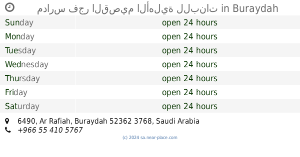
مدارس فجر القصيم الأهلية للبنات
6490, Buraydah
School
read more
718 m
Al-Qabas School
Buraydah
School
read more
722 m
Fajr Qassim Schools
الرفيعة
School
read more
764 m
22nd High School
Buraydah
School
read more
765 m
22nd Elementary School
Buraydah
School
read more
769 m
الروضة الثانية حي الرفيعة بريدة
شارع علي عبدالله السلمي, Buraydah
School
read more
818 m
المدرسة الابتدائية ٧٦
3982, Buraydah
School
read more
876 m
دار الأفق
6528, 52362،, Buraydah
School
read more
915 m
Buraidah High School
3812, 6630, Buraydah
School
read more
978 m
Jabal Al-Noor Elementary School
Umar Ibn Abdul Aziz Road, Buraydah
School
read more
1.006 km
Typical kindergarten buds ideas
7433, Buraydah
School
read more
1.015 km
Al Ahnaf Ibn Qais Intermediate School
Buraydah
School
read more
1.015 km
1st Intermediate School for Memorizing the Holy Quran
Buraydah
School
read more
1.017 km
1st High School for Memorizing the Holy Quran
King Khalid Road, Buraydah
School
read more
1.019 km
مسجد الجبر
6615, Buraydah
School
read more
1.028 km
Dar women of faith for the memorization of the Koran
7925, 3270, Buraydah
School
read more
1.029 km
مدارس ربيع الإيمان الأهلية
7922, Buraydah
School
read more
1.042 km
Islamic Solidarity Elementary School
Buraydah
School
read more
1.147 km
الثانوية الخامسة عشر مقررات ببريدة
-حي, Buraydah
School
read more
📑
all categories
Accounting
Administrative area level 1
Airport
Amusement park
Aquarium
Art gallery
Atm
Bakery
Bank
Bar
Beauty salon
Bicycle store
Book store
Bowling alley
Bus station
Cafe
Campground
Car dealer
Car rental
Car repair
Car wash
Casino
Cemetery
Church
City hall
Clothing store
Colloquial area
Convenience store
Country
Courthouse
Dentist
Department store
Doctor
Electrician
Electronics store
Embassy
Finance
Fire station
Florist
Food
Funeral home
Furniture store
Gas station
General contractor
Grocery or supermarket
Gym
Hair care
Hardware store
Health
Hindu Temple
Home goods store
Hospital
Insurance agency
Intersection
Jewelry store
Laundry
Lawyer
Library
Light rail station
Liquor store
Local government office
Locality
Locksmith
Lodging
Meal delivery
Meal takeaway
Mosque
Movie rental
Movie theater
Moving company
Museum
Natural feature
Neighborhood
Night club
Painter
Park
Parking
Pet store
Pharmacy
Physiotherapist
Place of worship
Plumber
Point of interest
Police
Political
Post office
Premise
Real estate agency
Restaurant
Roofing contractor
Route
Rv park, camping
School
Shoe store
Shopping mall
Spa
Stadium
Storage
Store
Sublocality
Subpremise
Subway station
Supermarket
Taxi stand
Train station
Transit station
Travel agency
University
Veterinary care
Zoo
sublocality level 1
↑