School nearby مدارس الإيمان الأهلية
Saudi Arabia
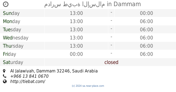
School nearby مدارس الإيمان الأهلية
مدارس الإيمان الأهلية
3931 Abu Al Hasan Al Wasty, Dammam Saudi Arabia
contacts phone
:
+966
Latitude:
26.4288069
, Longitude:
50.07019
read more
nearest School
26 m
مدارس طيبة الإسلام
Dammam
School
read more
28 m
مدارس الإيمان الأهلية
Dammam
School
read more
118 m
المدرسة الثانوية الخامسة للبنات
الدمام
School
read more
151 m
أ. نورس سلطان حسين
3931-4037 أبو الحسن الواسطي،, Dammam
School
read more
166 m
المدرسه الابتدائيه السابعه الدمام
17 Street, Dammam
School
read more
175 m
Adan Uniform Shop
7988 Prince Nayef Bin Abdulaziz Road, Dammam
School
read more
175 m
ثانوية خامسة مقررات الجلوية
8211 20 د, Dammam
School
read more
370 m
Imam Hafs center to teach the Holy Quran
Al Alaa Al Hadrami Street, Dammam
School
read more
437 m
26th Elementary girls' school
Dammam
School
read more
443 m
26th Intermediate School
Dammam
School
read more
449 m
مركز الشيخ سلطان العويد
Dammam
School
read more
449 m
مدرسة الشيخ سلطان العويد
Dammam
School
read more
456 m
معهد الشيخ سلطان لدراسات القرانية
Dammam
School
read more
469 m
26th Elementary School
Al Jalawiyah
School
read more
477 m
Institute of Intellectual Education for Girls
3921 ابو سعيد البغدادي, Dammam
School
read more
512 m
Medom School 2
8335 17, 4435,, Dammam
School
read more
571 m
الثانوية الثامنة عشر بالدمام
3832 Ar Ras, Dammam
School
read more
602 m
Easy Koranic schools
8279 16 ج, Dammam
School
read more
649 m
Girls Primary School 33
Shabeeb Ibn Ghaleb Street, Dammam
School
read more
665 m
Thirty School in Dammam
Nabyaniyah Street, Dammam
School
read more
673 m
Exams
Dammam
School
read more
692 m
ثانوية عكاظ
Dammam
School
read more
693 m
مدارس نوادر الأطفال الأهلية
شارع العلاء بن الحضرمي, الغلاء
School
read more
699 m
المدرسة العاشرة المتوسطة للبنات
القادسية،, Dammam
School
read more
715 m
روضة نوادر الأطفال الفرع ٢
Dammam
School
read more
📑
all categories
Accounting
Administrative area level 1
Airport
Amusement park
Aquarium
Art gallery
Atm
Bakery
Bank
Bar
Beauty salon
Bicycle store
Book store
Bowling alley
Bus station
Cafe
Campground
Car dealer
Car rental
Car repair
Car wash
Casino
Cemetery
Church
City hall
Clothing store
Colloquial area
Convenience store
Country
Courthouse
Dentist
Department store
Doctor
Electrician
Electronics store
Embassy
Finance
Fire station
Florist
Food
Funeral home
Furniture store
Gas station
General contractor
Grocery or supermarket
Gym
Hair care
Hardware store
Health
Hindu Temple
Home goods store
Hospital
Insurance agency
Intersection
Jewelry store
Laundry
Lawyer
Library
Light rail station
Liquor store
Local government office
Locality
Locksmith
Lodging
Meal delivery
Meal takeaway
Mosque
Movie rental
Movie theater
Moving company
Museum
Natural feature
Neighborhood
Night club
Painter
Park
Parking
Pet store
Pharmacy
Physiotherapist
Place of worship
Plumber
Point of interest
Police
Political
Post office
Premise
Real estate agency
Restaurant
Roofing contractor
Route
Rv park, camping
School
Shoe store
Shopping mall
Spa
Stadium
Storage
Store
Sublocality
Subpremise
Subway station
Supermarket
Taxi stand
Train station
Transit station
Travel agency
University
Veterinary care
Zoo
sublocality level 1
↑