School nearby مدرسة الأحنف بن قيس الابتدائية
Saudi Arabia
School nearby مدرسة الأحنف بن قيس الابتدائية
مدرسة الأحنف بن قيس الابتدائية
7365, 4403, Taif Saudi Arabia
contacts phone
:
+966
Latitude:
21.281801
, Longitude:
40.4041663
read more
nearest School
270 m
Your Excellencies the Civil School
Taif
School
read more
335 m
مركز التدريب الخاص بالمعلمات
7672, Taif
School
read more
354 m
Secondary education Kabarat Taif
مصلى العيد, Taif
School
read more
357 m
Trial for Girls in Taif
4478 Musala Al Id, Taif
School
read more
383 m
Elementary first Taif Girls
4524 مصلى العيد، العزيزية الطائف 26522 7044 Musala Al Id, Taif
School
read more
466 m
Bin Abi primary heel and medium trench
7349 الملك فيصل, Taif
School
read more
475 m
دار التوحيد الثانوية
4666 Musala Al Id, Taif
School
read more
487 m
إبتدائية أبي بن كعب ومتوسطة الخندق للبنين
Maashi
School
read more
547 m
ثانوية الفيصل للبنين
Maashi
School
read more
642 m
المدرسة العاشرة المتوسطة بنات
4989, Taif
School
read more
656 m
معهد الأمل الإبتدائي للبنين
Maashi
School
read more
677 m
Twenty Seven high school for girls
7941, 4688, Taif
School
read more
727 m
Dar Khadija for the memorization of the Koran
5096 Al Aqiq, Taif
School
read more
815 m
متوسطة المعالي الاهلية
5221 العقيق، العزيزية، الطائف 26522
School
read more
866 m
مدرسه العقيق الثانويه
7939, Taif
School
read more
884 m
Elementary Wael Ben Stone
5101, Taif
School
read more
916 m
Khwarizmi Institute
Shubra Street, Taif
School
read more
920 m
Alsun Language Center
Taif
School
read more
967 m
متوسطة أبي محجن الثقفي
7387 Shubra Street, Taif
School
read more
974 m
Social Guidance
Amru Al Qais, Taif
School
read more
993 m
مدرسة عبدالله بن ابي السرح الابتدائية
شارع الرفعي, Taif
School
read more
1.038 km
Abdul Aziz Bin Muammar Intermediate School
7850, Taif
School
read more
1.186 km
Boys Special Education Institute
Abu Bakr As Siddiq, Taif
School
read more
1.22 km
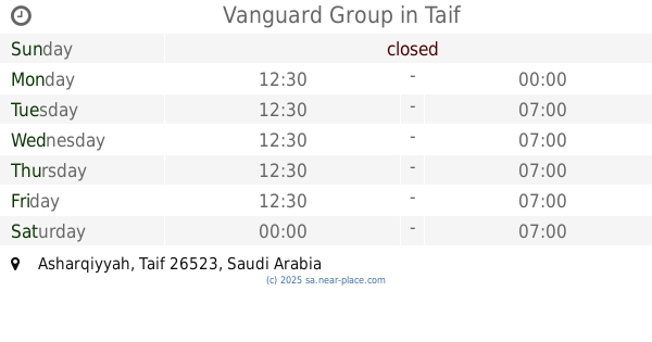
Vanguard Group
Taif
School
read more
1.229 km
روضة طيور الجنه
Tur Saina, Taif
School
read more
📑
all categories
Accounting
Administrative area level 1
Airport
Amusement park
Aquarium
Art gallery
Atm
Bakery
Bank
Bar
Beauty salon
Bicycle store
Book store
Bowling alley
Bus station
Cafe
Campground
Car dealer
Car rental
Car repair
Car wash
Casino
Cemetery
Church
City hall
Clothing store
Colloquial area
Convenience store
Country
Courthouse
Dentist
Department store
Doctor
Electrician
Electronics store
Embassy
Finance
Fire station
Florist
Food
Funeral home
Furniture store
Gas station
General contractor
Grocery or supermarket
Gym
Hair care
Hardware store
Health
Hindu Temple
Home goods store
Hospital
Insurance agency
Intersection
Jewelry store
Laundry
Lawyer
Library
Light rail station
Liquor store
Local government office
Locality
Locksmith
Lodging
Meal delivery
Meal takeaway
Mosque
Movie rental
Movie theater
Moving company
Museum
Natural feature
Neighborhood
Night club
Painter
Park
Parking
Pet store
Pharmacy
Physiotherapist
Place of worship
Plumber
Point of interest
Police
Political
Post office
Premise
Real estate agency
Restaurant
Roofing contractor
Route
Rv park, camping
School
Shoe store
Shopping mall
Spa
Stadium
Storage
Store
Sublocality
Subpremise
Subway station
Supermarket
Taxi stand
Train station
Transit station
Travel agency
University
Veterinary care
Zoo
sublocality level 1
↑