School nearby مدرسة جليل الابتدائية والمتوسطة بنين
Saudi Arabia
School nearby مدرسة جليل الابتدائية والمتوسطة بنين
مدرسة جليل الابتدائية والمتوسطة بنين
الطائف Saudi Arabia
contacts phone
:
+966
Latitude:
21.3911537
, Longitude:
40.5982124
read more
nearest School
351 m
مدرسة جليل الإبتدائية
Taif
School
read more
4.72 km
Alqoasm School for Girls
Taif
School
read more
5.581 km
Alqoasm High School for Boys
Taif
School
read more
5.682 km
مدرسة القويسم المتوسطة والثانوية للبنات
Taif
School
read more
5.845 km
مدرسة عمير ابن وهب وابن المقرب الابتدائية والمتوسطة
Taif
School
read more
5.848 km
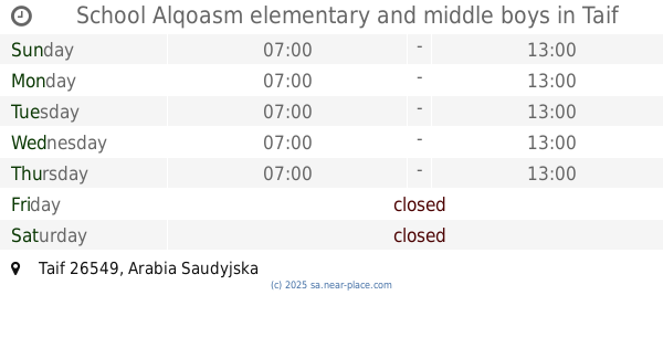
School Alqoasm elementary and middle boys
Taif
School
read more
6.743 km
مسجد المالكي
Taif
School
read more
7.62 km
Elementary with good girls
Taif
School
read more
8.617 km
Rumeida primary
Taif
School
read more
10.127 km
مدرسة عقيل بن أبي طالب الابتدائية للبنين
4548, 8692, Taif
School
read more
10.157 km
تحفيظ القرآن الكريم الثانوية بالقاعدة للبنين
Taif
School
read more
10.165 km
Middle and high memorization air base
4548, Taif
School
read more
10.167 km
Memorization of the Holy Quran Complex schools
4531, Taif
School
read more
10.228 km
High School nine o'clock
Taif
School
read more
10.228 km
Pakistani internation school Taif
Taif
School
read more
10.228 km
Secondary Imam Malik
Taif
School
read more
10.228 km
International Indian School Taif
Near Al ameen hospital, 21944, Taif
School
read more
10.235 km
Training Center Founding Air Force
2615, Taif
School
read more
10.281 km
Umm Al Qura School
7063, Taif
School
read more
10.492 km
مدرسة عبدالرحمن بن عوف الإبتدائية
6295, Taif
School
read more
10.501 km
School Samra bin medium Jundub Benin
6353, Taif
School
read more
10.508 km
King Abdulaziz High School for males
Taif
School
read more
10.508 km
Sidra School
Taif
School
read more
10.789 km
المتوسطة الثامنة للبنات
2756, 7665, Taif
School
read more
10.805 km
Kindergarten third Bahoih
2740, Taif
School
read more
📑
all categories
Accounting
Administrative area level 1
Airport
Amusement park
Aquarium
Art gallery
Atm
Bakery
Bank
Bar
Beauty salon
Bicycle store
Book store
Bowling alley
Bus station
Cafe
Campground
Car dealer
Car rental
Car repair
Car wash
Casino
Cemetery
Church
City hall
Clothing store
Colloquial area
Convenience store
Country
Courthouse
Dentist
Department store
Doctor
Electrician
Electronics store
Embassy
Finance
Fire station
Florist
Food
Funeral home
Furniture store
Gas station
General contractor
Grocery or supermarket
Gym
Hair care
Hardware store
Health
Hindu Temple
Home goods store
Hospital
Insurance agency
Intersection
Jewelry store
Laundry
Lawyer
Library
Light rail station
Liquor store
Local government office
Locality
Locksmith
Lodging
Meal delivery
Meal takeaway
Mosque
Movie rental
Movie theater
Moving company
Museum
Natural feature
Neighborhood
Night club
Painter
Park
Parking
Pet store
Pharmacy
Physiotherapist
Place of worship
Plumber
Point of interest
Police
Political
Post office
Premise
Real estate agency
Restaurant
Roofing contractor
Route
Rv park, camping
School
Shoe store
Shopping mall
Spa
Stadium
Storage
Store
Sublocality
Subpremise
Subway station
Supermarket
Taxi stand
Train station
Transit station
Travel agency
University
Veterinary care
Zoo
sublocality level 1
↑