School nearby مركز دار الإكليل للفتيات
Saudi Arabia
School nearby مركز دار الإكليل للفتيات
مركز دار الإكليل للفتيات
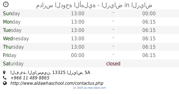
Al Yasmin, Riyadh 13325, Saudi-Arabien
contacts phone
:
+53 23 98113
Latitude:
24.8190418
, Longitude:
46.6246757
larger map & directions
read more
nearest School
10 m
School House Coronal
3074, Riyadh
School
read more
166 m
روضة 72
Riyadh
School
read more
171 m
الروضة ٧٢ kindergarten72
Riyadh
School
read more
221 m
Educational Age International Schools
الرحاب, Riyadh
School
read more
261 m
مدارس الدوحة الأهلية - الرياض
الفرعة، الياسمين، الرياض
School
read more
435 m
Kindergarten jasmine-civil Trace Collector Obouhamd
3513, Riyadh
School
read more
449 m
دار الياسمين
3588, 6986, Riyadh
School
read more
450 m
دار الياسمين لتحفيظ القرآن الكريم
6969, Riyadh
School
read more
736 m
Baraem Rowad Alkhaleej Int. School براعم رواد الخليج العالميه
Prince Abdullah Bin Saud Bin Abdullah Snatan Al Saud, Riyadh
School
read more
741 m
Global kindergartens Gulf buds
السدره, Riyadh
School
read more
826 m
الكلية التقنية بالرس
Ar Rass, Riyadh
School
read more
840 m
مدرسة نورة السويلم لتحفيط القران الكريم
7049, 3919, Riyadh
School
read more
865 m
High School Saud al-Faisal
Riyadh
School
read more
976 m
مدرسة الامير سعود الفيصل
300 رقم، الياسمين،, Riyadh
School
read more
1.092 km
Institute of Health Sciences
4078, Riyadh
School
read more
1.216 km
School Necmettin
3601, Riyadh
School
read more
1.24 km
عبدالله بن ذكوان لتحفيظ القرآن الكريم
Unnamed Road, Riyadh
School
read more
1.258 km
ابتدائية عبدالله بن ذكوان لتحفيظ القرأن
3601, Riyadh
School
read more
1.261 km
International Indian Public School
Main Gate 3, H.E Ali Naimi Street, Dhahran
School
read more
1.261 km
مدرسة نجم الدين ايوب المتوسطة
3601, Riyadh
School
read more
1.263 km
ابتدائية عبدالله ابن ذكوان
3601, Riyadh
School
read more
1.269 km
Medium Star Ayyubid Religion
3580, Riyadh
School
read more
1.309 km
ابتدائية الملقا
3516, Riyadh
School
read more
1.337 km
مدرسة حي الملقا الابتدائية
3601, Riyadh
School
read more
1.5 km
English
8255 Al Najma, Riyadh
School
read more
📑
all categories
Accounting
Administrative area level 1
Airport
Amusement park
Aquarium
Art gallery
Atm
Bakery
Bank
Bar
Beauty salon
Bicycle store
Book store
Bowling alley
Bus station
Cafe
Campground
Car dealer
Car rental
Car repair
Car wash
Casino
Cemetery
Church
City hall
Clothing store
Colloquial area
Convenience store
Country
Courthouse
Dentist
Department store
Doctor
Electrician
Electronics store
Embassy
Finance
Fire station
Florist
Food
Funeral home
Furniture store
Gas station
General contractor
Grocery or supermarket
Gym
Hair care
Hardware store
Health
Hindu Temple
Home goods store
Hospital
Insurance agency
Intersection
Jewelry store
Laundry
Lawyer
Library
Light rail station
Liquor store
Local government office
Locality
Locksmith
Lodging
Meal delivery
Meal takeaway
Mosque
Movie rental
Movie theater
Moving company
Museum
Natural feature
Neighborhood
Night club
Painter
Park
Parking
Pet store
Pharmacy
Physiotherapist
Place of worship
Plumber
Point of interest
Police
Political
Post office
Premise
Real estate agency
Restaurant
Roofing contractor
Route
Rv park, camping
School
Shoe store
Shopping mall
Spa
Stadium
Storage
Store
Sublocality
Subpremise
Subway station
Supermarket
Taxi stand
Train station
Transit station
Travel agency
University
Veterinary care
Zoo
sublocality level 1
↑