School nearby ثانوية الامير سلطان بن عبدالعزيز
Saudi Arabia
School nearby ثانوية الامير سلطان بن عبدالعزيز
ثانوية الامير سلطان بن عبدالعزيز
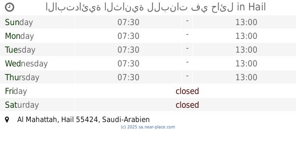
Falastin, Hail Saudi Arabia
contacts phone
:
+966
Latitude:
27.5258649
, Longitude:
41.6788405
read more
nearest School
143 m
متوسطة طيبة بنين
4231 النابغة الزبيانى, Hail
School
read more
279 m
الابتدائية 32
8084، العزيزية، حائل 55424
School
read more
280 m
الابتدائية الثانية والثلاثون للبنات
4392 جندب بن عمار, Hail
School
read more
319 m
The new secondary glory civil
King Faisal Road, Hail
School
read more
428 m
الابتدائية الثامنه عشر
4441 شداش بن اوس, Hail
School
read more
433 m
Elementary eighteen Girls
4441 شداش بن اوس, Hail
School
read more
481 m
مدرسة الرياض المتوسطة
Falastin, Hail
School
read more
486 m
مدرسة الخامسه المتوسطه
8520 Falastin, Hail
School
read more
494 m
متوسطة الرياض
8520 Falastin, Hail
School
read more
522 m
The first kindergarten
4513 موسى بن نصير, Hail
School
read more
551 m
الابتدائية الثانية للبنات في حائل
Hail
School
read more
552 m
الابتدائية الثانية عشرة للبنات
3634 الملك فيصل, Hail
School
read more
577 m
مجمع مدارس أجيال حائل الأهلية
7538, Hail
School
read more
578 m
Elementary school third Koranic
Hail
School
read more
579 m
مدارس أجيال حائل للبنات
Hail
School
read more
593 m
Chamber III Koranic for Girls
Hail
School
read more
620 m
المتوسطة الثانية للبنات
7584 عائشة ام المؤمنين, Hail
School
read more
642 m
Second Elementary School Girls Hail
Aishah Umm Al Muminin, Tathleeth
School
read more
677 m
ثانوية الامير مقرن
Al Wusayta
School
read more
699 m
ثانوية الأمير مقرن بن عبدالعزيز
3866 Uqdah Road, Hail
School
read more
719 m
مركز تدريب رياض الأطفال
7593 عائشة ام المؤمنين, Hail
School
read more
755 m
المدرسة الثانوية الاولئ (بنات)
4686 عائشة ام المؤمنين, Hail
School
read more
759 m
متوسطة الملك خالد
3988, Hail
School
read more
767 m
Amr ibn al-Aas Primary School
3686 طريق عقدة، الوسيطاء حائل 55424 7369 Uqdah Road, Hail
School
read more
768 m
قصر الشيخ ملحان بن بصيص
Al Wusayta, Hail
School
read more
📑
all categories
Accounting
Administrative area level 1
Airport
Amusement park
Aquarium
Art gallery
Atm
Bakery
Bank
Bar
Beauty salon
Bicycle store
Book store
Bowling alley
Bus station
Cafe
Campground
Car dealer
Car rental
Car repair
Car wash
Casino
Cemetery
Church
City hall
Clothing store
Colloquial area
Convenience store
Country
Courthouse
Dentist
Department store
Doctor
Electrician
Electronics store
Embassy
Finance
Fire station
Florist
Food
Funeral home
Furniture store
Gas station
General contractor
Grocery or supermarket
Gym
Hair care
Hardware store
Health
Hindu Temple
Home goods store
Hospital
Insurance agency
Intersection
Jewelry store
Laundry
Lawyer
Library
Light rail station
Liquor store
Local government office
Locality
Locksmith
Lodging
Meal delivery
Meal takeaway
Mosque
Movie rental
Movie theater
Moving company
Museum
Natural feature
Neighborhood
Night club
Painter
Park
Parking
Pet store
Pharmacy
Physiotherapist
Place of worship
Plumber
Point of interest
Police
Political
Post office
Premise
Real estate agency
Restaurant
Roofing contractor
Route
Rv park, camping
School
Shoe store
Shopping mall
Spa
Stadium
Storage
Store
Sublocality
Subpremise
Subway station
Supermarket
Taxi stand
Train station
Transit station
Travel agency
University
Veterinary care
Zoo
sublocality level 1
↑