Shopping mall nearby مجمع الصديق التجاري
Saudi Arabia
Shopping mall nearby مجمع الصديق التجاري
مجمع الصديق التجاري
Buraydah 52388, Saudi Arabia
contacts phone
:
+966
Latitude:
26.410141
, Longitude:
43.9317385
larger map & directions
read more
nearest Shopping mall
248 m
جليانة للتدفئة ولوازم الرحلات
Buraydah
Shopping mall
read more
257 m
تموينات
3398, مخطط الرواف مخطط الرواف،, Buraydah
Shopping mall
read more
320 m
زينة الشمال
Abu Bakr As Siddiq Road, Buraydah
Shopping mall
read more
487 m
ماجستك سيرفس
Uthman Ibn Affan Road, Buraydah
Shopping mall
read more
697 m
مشغل فايوليت بيوتي
Buraydah
Shopping mall
read more
722 m
Ghannam Trade Center
King Abdullah Road, Buraydah
Shopping mall
read more
725 m
مذاق القهوة
Uthman Ibn Affan Road, بريدة - حي النهضه, Buraydah
Shopping mall
read more
786 m
متجر غرام
Buraydah
Shopping mall
read more
811 m
متجر غرام
Uthman Ibn Affan Road, Buraydah
Shopping mall
read more
851 m
شجرة اللوز
Uthman Ibn Affan Road, بريده،حي النهضه،, Buraydah
Shopping mall
read more
968 m
حلويات استاج سويت
Buraydah
Shopping mall
read more
969 m
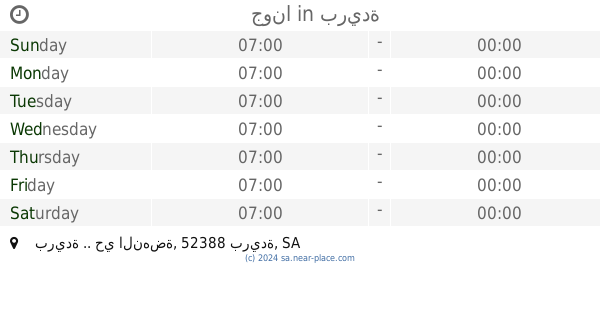
جونا
بريدة .. حي النهضة، بريدة
Shopping mall
read more
983 m
Nora Candles Beauty
Uthman Ibn Affan Road, بريدة حي النهضة طريق عثمان لن عفان مقابل اسواق العثيم, Buraydah
Shopping mall
read more
986 m
جريدة الوسيله ببريده
Buraydah
Shopping mall
read more
995 m
الوسيلة الاعلانية
Buraydah
Shopping mall
read more
1.002 km
حلوالألعاب
6875 طريق عثمان بن عفان، مخطط الرواف بريدة 52388 3633 Uthman Ibn Affan Road, Buraydah
Shopping mall
read more
1.012 km
حلول التغذية
Uthman Ibn Affan Road, Buraydah
Shopping mall
read more
1.023 km
النجيلة الصناعية
شارع As Sinaah, Buraydah
Shopping mall
read more
1.202 km
محاصيل الخير
Omar Bin Al-Khattab Road، بريدة
Shopping mall
read more
1.209 km
ثمار مزرعتي للخضار
Uthman Ibn Affan Road, Buraydah
Shopping mall
read more
1.223 km
مفتاحي
Buraydah
Shopping mall
read more
1.223 km
محل مفتاحي للمفاتيح
Buraydah
Shopping mall
read more
1.231 km
روعة مفرشي للمفارش
5288, مخطط الرواف،, Buraydah
Shopping mall
read more
1.26 km
Geleanp Sweets
طريق عمر بن الخطاب Umar Ibn Al Khatab Road, Buraydah
Shopping mall
read more
1.264 km
دهانات الجزيرة
Umar Ibn Al Khatab Road, بريدة الراشديات, Buraydah
Shopping mall
read more
📑
all categories
Accounting
Administrative area level 1
Airport
Amusement park
Aquarium
Art gallery
Atm
Bakery
Bank
Bar
Beauty salon
Bicycle store
Book store
Bowling alley
Bus station
Cafe
Campground
Car dealer
Car rental
Car repair
Car wash
Casino
Cemetery
Church
City hall
Clothing store
Colloquial area
Convenience store
Country
Courthouse
Dentist
Department store
Doctor
Electrician
Electronics store
Embassy
Finance
Fire station
Florist
Food
Funeral home
Furniture store
Gas station
General contractor
Grocery or supermarket
Gym
Hair care
Hardware store
Health
Hindu Temple
Home goods store
Hospital
Insurance agency
Intersection
Jewelry store
Laundry
Lawyer
Library
Light rail station
Liquor store
Local government office
Locality
Locksmith
Lodging
Meal delivery
Meal takeaway
Mosque
Movie rental
Movie theater
Moving company
Museum
Natural feature
Neighborhood
Night club
Painter
Park
Parking
Pet store
Pharmacy
Physiotherapist
Place of worship
Plumber
Point of interest
Police
Political
Post office
Premise
Real estate agency
Restaurant
Roofing contractor
Route
Rv park, camping
School
Shoe store
Shopping mall
Spa
Stadium
Storage
Store
Sublocality
Subpremise
Subway station
Supermarket
Taxi stand
Train station
Transit station
Travel agency
University
Veterinary care
Zoo
sublocality level 1
↑