Supermarket nearby Al waleed flour mill
Saudi Arabia
Supermarket nearby Al waleed flour mill
Al waleed flour mill
2409, Al Udaba, 23342, Jeddah, SA Saudi Arabia
contacts phone
:
+966 56 157 2495
Latitude:
21.5578971
, Longitude:
39.2057908
larger map & directions
read more
nearest Supermarket
68 m
Al Mehran Store
2471 Al Udaba, Al Aziziyah District,, Jeddah
Supermarket
read more
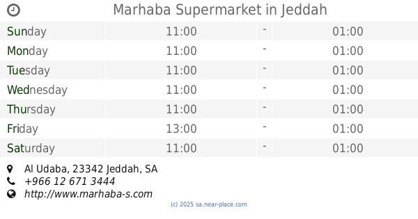
136 m
Marhaba Supermarket
Al Udaba, Jeddah
Supermarket
read more
147 m
Marhaba Azizia
Rifaah At Tahtawi, Jeddah
Supermarket
read more
147 m
Marhaba Shopping Centre
Rifaah At Tahtawi, Jeddah
Supermarket
read more
296 m
Taiba Supermarket
Al Muarrikhin, Jeddah
Supermarket
read more
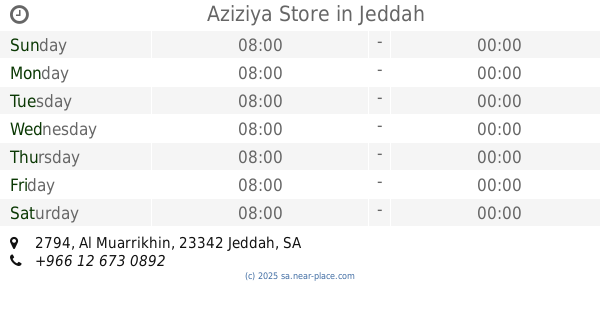
390 m
Aziziya Store
2794 Al Muarrikhin, Al Aziziyah District,, Jeddah
Supermarket
read more
422 m
Aziziya Food Store
2493 Ahmad Almadani, 8139, Jeddah
Supermarket
read more
450 m
Zaiqa Food Center
طريق الأمير ماجد, Jeddah
Supermarket
read more
469 m
Al Azizia Flour Store
2354-2442 Al Muallifeen Street, Jeddah
Supermarket
read more
476 m
ماركت السعودية
4855-4869 العزيزية،، جدة
Supermarket
read more
480 m
National Supermarket
طريق الأمير ماجد, Jeddah
Supermarket
read more
518 m
تموينات الإمتياز للمواد الغذائية
شارع المؤلفين، حي العزيزية، جدة
Supermarket
read more
526 m
Kedai Asia
Al Muallifeen Street, Jeddah
Supermarket
read more
630 m
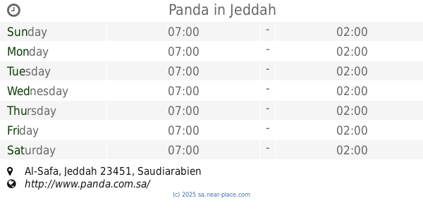
Panda
Jeddah
Supermarket
read more
632 m
بنده
Supermarket
read more
632 m
PANDA 201 JEDDAH, SAFA
Supermarket
read more
640 m
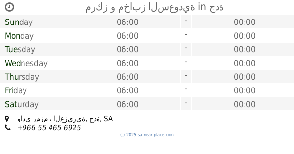
مركز و مخابز السعودية
وادي زمزم ، العزيزية، جدة
Supermarket
read more
658 m
PANDA 201 JEDDAH, SAFA
Tahlia Street, Intersection
Supermarket
read more
692 m
سوبرماركت بريمو
Jeddah
Supermarket
read more
769 m
Carrefour
4965 Prince Majid Rd، جدة
Supermarket
read more
769 m
Carrefour
4965 Prince Majid Road, Jeddah
Supermarket
read more
769 m
Carrefour Saudi
4965 Prince Majid Road, Jeddah
Supermarket
read more
770 m
Carrefour Flamingo Mall
Prince Majid Road, Jeddah
Supermarket
read more
770 m
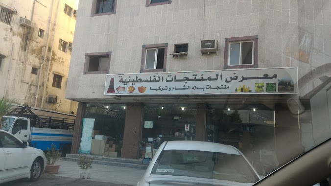
المنتجات الفلسطينية
2851 الامير محمد بن عبدالعزيز, Al Aziziyah District, 9165, Jeddah
Supermarket
read more
783 m
Knight Motorcycle
Gate 6, 21°33'43. 39°11'59.0"E, Jeddah
Supermarket
read more
📑
all categories
Accounting
Administrative area level 1
Airport
Amusement park
Aquarium
Art gallery
Atm
Bakery
Bank
Bar
Beauty salon
Bicycle store
Book store
Bowling alley
Bus station
Cafe
Campground
Car dealer
Car rental
Car repair
Car wash
Casino
Cemetery
Church
City hall
Clothing store
Colloquial area
Convenience store
Country
Courthouse
Dentist
Department store
Doctor
Electrician
Electronics store
Embassy
Finance
Fire station
Florist
Food
Funeral home
Furniture store
Gas station
General contractor
Grocery or supermarket
Gym
Hair care
Hardware store
Health
Hindu Temple
Home goods store
Hospital
Insurance agency
Intersection
Jewelry store
Laundry
Lawyer
Library
Light rail station
Liquor store
Local government office
Locality
Locksmith
Lodging
Meal delivery
Meal takeaway
Mosque
Movie rental
Movie theater
Moving company
Museum
Natural feature
Neighborhood
Night club
Painter
Park
Parking
Pet store
Pharmacy
Physiotherapist
Place of worship
Plumber
Point of interest
Police
Political
Post office
Premise
Real estate agency
Restaurant
Roofing contractor
Route
Rv park, camping
School
Shoe store
Shopping mall
Spa
Stadium
Storage
Store
Sublocality
Subpremise
Subway station
Supermarket
Taxi stand
Train station
Transit station
Travel agency
University
Veterinary care
Zoo
sublocality level 1
↑