Supermarket nearby اسواق ومخابز العمرانى
Saudi Arabia
Supermarket nearby اسواق ومخابز العمرانى
اسواق ومخابز العمرانى
3332 Ash Shutbah, Taif Saudi Arabien
contacts phone
:
+966
Latitude:
21.2572033
, Longitude:
40.4191953
read more
nearest Supermarket
95 m
Maliki Supermarket
7545 Nijyraiyah, Taif
Supermarket
read more
134 m
Aidaroos Spices
شارع 25, Taif
Supermarket
read more
169 m
Alwaleed Super Market
Tuns, Taif
Supermarket
read more
404 m
سلة ومخبز وطني
2696 Wadi Hanifah, Taif
Supermarket
read more
511 m
تموينات النزهة
النزهة/، الطائف
Supermarket
read more
545 m
Ben Hovan market
8170 25, 3188, Taif
Supermarket
read more
584 m
Nuzah Bakery Shop
7951 Ali Ibn Al Khatab, Taif
Supermarket
read more
691 m
بقالة المالكي
شارع التلفزيون، الطائف
Supermarket
read more
718 m
Svat Gulf Waves
An Nuzhah, Taif
Supermarket
read more
718 m
Svat Gulf Waves
النزهة النزهة, Taif
Supermarket
read more
757 m
Alwaleed Supermarket
Al Suwaidan, Taif
Supermarket
read more
838 m
Khaled Supermarket
At Tilfizyun, Taif
Supermarket
read more
949 m
سوبرماركت المجد للمواد الغذائية
7390 At Tilfizyun, Taif
Supermarket
read more
975 m
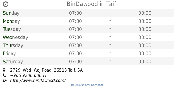
BinDawood
2729 Wadi Waj Road, Taif
Supermarket
read more
987 m
مؤسسةالعسيري للمواد الغذائية
الشهداء الجنوبية، الطائف
Supermarket
read more
1.004 km
ثلاجة العرابي
8658 Al Iraq, Taif
Supermarket
read more
1.006 km
Sellaga Al Arabi
8663 Al Iraq, Taif
Supermarket
read more
1.107 km
Hyper Panda Taif
Hassan Ibn Thabit, Taif
Supermarket
read more
1.107 km
Heart Taif Refrigerator
Qatar, Taif
Supermarket
read more
1.274 km
سوبر ماركت محطة الأفق
Taif
Supermarket
read more
1.288 km
Alrayah
Taif
Supermarket
read more
1.319 km
بقالة بن عائض
Unnamed Road, حوايا،, Taif
Supermarket
read more
1.406 km
سوبر ماركت النور للمواد الغذائية
8625 قرينط، الشهداء الشمالية الطائف 26513 4080 Qurint, Taif
Supermarket
read more
1.421 km
سوبرماركت ومخابز السحاب للتسوق للمواد الغذائية
Taif
Supermarket
read more
1.46 km
Alanoud Hyper Market
Taif
Supermarket
read more
📑
all categories
Accounting
Administrative area level 1
Airport
Amusement park
Aquarium
Art gallery
Atm
Bakery
Bank
Bar
Beauty salon
Bicycle store
Book store
Bowling alley
Bus station
Cafe
Campground
Car dealer
Car rental
Car repair
Car wash
Casino
Cemetery
Church
City hall
Clothing store
Colloquial area
Convenience store
Country
Courthouse
Dentist
Department store
Doctor
Electrician
Electronics store
Embassy
Finance
Fire station
Florist
Food
Funeral home
Furniture store
Gas station
General contractor
Grocery or supermarket
Gym
Hair care
Hardware store
Health
Hindu Temple
Home goods store
Hospital
Insurance agency
Intersection
Jewelry store
Laundry
Lawyer
Library
Light rail station
Liquor store
Local government office
Locality
Locksmith
Lodging
Meal delivery
Meal takeaway
Mosque
Movie rental
Movie theater
Moving company
Museum
Natural feature
Neighborhood
Night club
Painter
Park
Parking
Pet store
Pharmacy
Physiotherapist
Place of worship
Plumber
Point of interest
Police
Political
Post office
Premise
Real estate agency
Restaurant
Roofing contractor
Route
Rv park, camping
School
Shoe store
Shopping mall
Spa
Stadium
Storage
Store
Sublocality
Subpremise
Subway station
Supermarket
Taxi stand
Train station
Transit station
Travel agency
University
Veterinary care
Zoo
sublocality level 1
↑