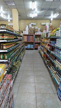
Supermarket nearby سوبر ماركت الريان
Coronavirus disease (COVID-19) Situation
confirmed cases
841469
deaths
9646
Saudi Arabia
Supermarket nearby سوبر ماركت الريان
سوبر ماركت الريان
آل السريع Saudi Arabia
contacts phone
:
+966
Latitude:
18.1728216
, Longitude:
42.6302828
read more
nearest Supermarket
2 m
اسواق الريان المركزية
آل السريع
Supermarket
read more
800 m
سوبر ماركت المحارث
آل السريع
Supermarket
read more
4.038 km
اسواق نسيمي
Abha
Supermarket
read more
5.845 km
احمد النحال
طريق عضاضة, Al Sarhan
Supermarket
read more
6.715 km
بقالة البركه
Abha
Supermarket
read more
7.171 km
زيد الخير
حي الموظفين، أبها
Supermarket
read more
7.358 km
مركز الموظفين للتسوق
حي الموظفين، أبها
Supermarket
read more
7.465 km
Market Bakery Promoter Abha
Abha
Supermarket
read more
7.612 km
alsalam grocery
Abha
Supermarket
read more
7.774 km
برج البديع للمقاولات العامة والعقار
8680, 5248, Abha
Supermarket
read more
7.972 km
بنده
King Fahd Road, Abha
Supermarket
read more
8.034 km
Good market
المزوين، ابها
Supermarket
read more
8.124 km
مركز إمداد العائلة للمواد الغذائية
Abha
Supermarket
read more
8.129 km
سوق العندليب
حي الموظفين، أبها
Supermarket
read more
8.13 km
بقالة محمد
5420, Abha
Supermarket
read more
8.185 km
سوبر ماركت حي الموظفين
حي الموظفين، أبها
Supermarket
read more
8.875 km
بنده الراشد مول أبها
King Fahd Road, Abha
Supermarket
read more
8.875 km
Panda
King Fahd Road, Abha
Supermarket
read more
8.905 km
Panda Market
4366, Abha
Supermarket
read more
9.23 km
ماركت كنج
Supermarket
read more
9.254 km
سوبر ماركت روابي تهامة
المروج،, Abha
Supermarket
read more
9.286 km
Amer markets
King Fahd Branch Road, Abha
Supermarket
read more
9.48 km
UNIVERSAL COLD STORE
كوبري المطار, abha,Sultan city king Fahad street near Kobri airport مدينة سلطان شارع الملك فهد قبل, Abha
Supermarket
read more
9.496 km
Prime Universal Cold Stores
طريق الملك فهد العام، أبها
Supermarket
read more
9.504 km
Othaim Markets
King Fahd Road, Abha
Supermarket
read more
📑
all categories
Accounting
Administrative area level 1
Airport
Amusement park
Aquarium
Art gallery
Atm
Bakery
Bank
Bar
Beauty salon
Bicycle store
Book store
Bowling alley
Bus station
Cafe
Campground
Car dealer
Car rental
Car repair
Car wash
Casino
Cemetery
Church
City hall
Clothing store
Colloquial area
Convenience store
Country
Courthouse
Dentist
Department store
Doctor
Electrician
Electronics store
Embassy
Finance
Fire station
Florist
Food
Funeral home
Furniture store
Gas station
General contractor
Grocery or supermarket
Gym
Hair care
Hardware store
Health
Hindu Temple
Home goods store
Hospital
Insurance agency
Intersection
Jewelry store
Laundry
Lawyer
Library
Light rail station
Liquor store
Local government office
Locality
Locksmith
Lodging
Meal delivery
Meal takeaway
Mosque
Movie rental
Movie theater
Moving company
Museum
Natural feature
Neighborhood
Night club
Painter
Park
Parking
Pet store
Pharmacy
Physiotherapist
Place of worship
Plumber
Point of interest
Police
Political
Post office
Premise
Real estate agency
Restaurant
Roofing contractor
Route
Rv park, camping
School
Shoe store
Shopping mall
Spa
Stadium
Storage
Store
Sublocality
Subpremise
Subway station
Supermarket
Taxi stand
Train station
Transit station
Travel agency
University
Veterinary care
Zoo
sublocality level 1
↑