Atm nearby Al Rajhi ATM
Saudi Arabia
Atm nearby Al Rajhi ATM
Al Rajhi ATM
4266، An Nasiriyyah, Buraydah 52333, Saudi Arabia
contacts phone
:
+966 9200 03344
website:
www.alrajhibank.com.sa
Latitude:
26.2822864
, Longitude:
43.9825902
larger map & directions
read more
nearest Atm
1.353 km
Al Rajhi ATM
8024 As Salimiyyah, Buraydah
Atm
read more
1.37 km
Riyad ATM
8084 As Salimiyyah, Buraydah
Atm
read more
2.555 km
Alinma ATM
Al Huwailan, Buraydah
Atm
read more
2.717 km
Albilad ATM
King Abdulaziz Road, Yaser G/S, Abana, Buraydah
Atm
read more
3.239 km
Al Rajhi ATM
Al Huwailan, Buraydah
Atm
read more
3.367 km
Al Rajhi ATM
سوق الماشية, Buraydah
Atm
read more
3.427 km
Riyad ATM
7454 King Abdulaziz Road, Buraydah
Atm
read more
3.671 km
Exchange National Bank
Buraydah
Atm
read more
3.766 km
Al Rajhi ATM
As Sabbakh, Buraydah
Atm
read more
3.985 km
Saudi ATM Investment
6726 Al Qanat, Buraydah
Atm
read more
4.068 km
Al Rajhi ATM
سوق الماشية، بريدة
Atm
read more
4.091 km
NCB ATM
King Abdulaziz Road, Buraydah
Atm
read more
4.148 km
Bank Albilad ATM
King Abdulaziz Road, Buraydah
Atm
read more
4.23 km
الأهلي
شارع الصباخ، بريدة
Atm
read more
4.238 km
Al Rajhi ATM
7312, 4387, Buraydah
Atm
read more
4.327 km
Al Rajhi ATM
Khudayra Road, Buraydah
Atm
read more
4.374 km
Riyad ATM
6875 Khudayra Road, Buraydah
Atm
read more
4.394 km
Riyad Bank
شارع الصباخ، بريدة
Atm
read more
4.394 km
بنك الرياض
شارع الصباخ، بريدة
Atm
read more
4.49 km
Al Rajhi ATM
As Sabbakh, سوق الخضار, Buraydah
Atm
read more
4.507 km
Riyad ATM
7575, 4268, Buraydah
Atm
read more
4.587 km
مصرف الراجحي
الموطا، بريدة
Atm
read more
4.634 km
Al Rajhi ATM
4121, Buraydah
Atm
read more
4.665 km
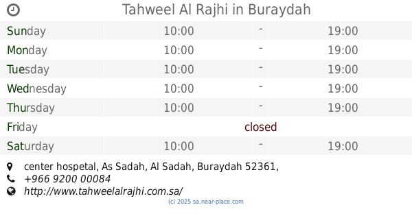
Tahweel Al Rajhi
center hospetal, Al Sadah, Buraydah
Atm
read more
4.717 km
SABB ATM
King Faisal Road, Buraydah
Atm
read more
📑
all categories
Accounting
Administrative area level 1
Airport
Amusement park
Aquarium
Art gallery
Atm
Bakery
Bank
Bar
Beauty salon
Bicycle store
Book store
Bowling alley
Bus station
Cafe
Campground
Car dealer
Car rental
Car repair
Car wash
Casino
Cemetery
Church
City hall
Clothing store
Colloquial area
Convenience store
Country
Courthouse
Dentist
Department store
Doctor
Electrician
Electronics store
Embassy
Finance
Fire station
Florist
Food
Funeral home
Furniture store
Gas station
General contractor
Grocery or supermarket
Gym
Hair care
Hardware store
Health
Hindu Temple
Home goods store
Hospital
Insurance agency
Intersection
Jewelry store
Laundry
Lawyer
Library
Light rail station
Liquor store
Local government office
Locality
Locksmith
Lodging
Meal delivery
Meal takeaway
Mosque
Movie rental
Movie theater
Moving company
Museum
Natural feature
Neighborhood
Night club
Painter
Park
Parking
Pet store
Pharmacy
Physiotherapist
Place of worship
Plumber
Point of interest
Police
Political
Post office
Premise
Real estate agency
Restaurant
Roofing contractor
Route
Rv park, camping
School
Shoe store
Shopping mall
Spa
Stadium
Storage
Store
Sublocality
Subpremise
Subway station
Supermarket
Taxi stand
Train station
Transit station
Travel agency
University
Veterinary care
Zoo
sublocality level 1
↑