Bank nearby مجمع دوائر حكومية
Coronavirus disease (COVID-19) Situation
confirmed cases
841469
deaths
9646
Saudi Arabia
Bank nearby مجمع دوائر حكومية
مجمع دوائر حكومية
Riyadh Arabia Saudyjska
contacts phone
:
+966
Latitude:
24.8435713
, Longitude:
46.7122887
read more
nearest Bank
1.747 km
صراف بنك الرياض
Unnamed Road، الرياض
Bank
read more
1.747 km
Riyad Bank
Unnamed Road، الرياض
Bank
read more
2.902 km
Villa Abou Abdullah Narjis
No. 115, Riyadh
Bank
read more
3.562 km
ATM مصرف الانماء
Ath Thumamah Road, Riyadh
Bank
read more
3.668 km
Al Bilad
149 al moorog branch, Riyadh
Bank
read more
3.761 km
Tashuwer تشاور للاستشارات المالية
Riyadh
Bank
read more
4.14 km
قرطبه
الرياض
Bank
read more
4.185 km
Swissport KSA
8260 Airport Road, Riyadh
Bank
read more
4.341 km
Bank Aljazira ATM
Said Ibn Zayd Road, Riyadh
Bank
read more
4.35 km
Bank Aljazira بنك الجزيرة
Riyadh
Bank
read more
4.697 km
National Commercial Bank
الرياض
Bank
read more
4.757 km
Riyad Bank
Riyadh
Bank
read more
5.016 km
AlRajhi Bank
Said Ibn Zayd Road, Riyadh
Bank
read more
5.235 km
بنك الاستثمار السعودي - الوادي
Riyadh
Bank
read more
5.479 km
Riyad Bank
Dammam Road, Riyadh
Bank
read more
5.495 km
البنك الأول
Uthman Ibn Affan Road, 7147, 2367, Riyadh
Bank
read more
5.499 km
Alawwal Bank البنك الأول
7147 Uthman Ibn Affan Road, Riyadh
Bank
read more
5.511 km
البنك الاهلي
Riyadh
Bank
read more
5.512 km
SHAR Company
جرير, Riyadh
Bank
read more
5.519 km
NCB
Dammam Branch Road, Riyadh
Bank
read more
5.546 km
Alinma Bank
Dammam Branch Road, Riyadh
Bank
read more
5.565 km
عيادات ريانه
طريق ابي بكر الصديق،، الرياض
Bank
read more
5.638 km
صرافةالاهلي
6838, Al Yasmin, Riyadh
Bank
read more
5.65 km
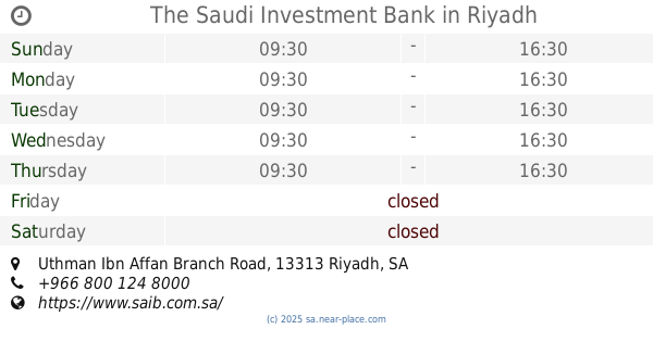
The Saudi Investment Bank
Uthman Ibn Affan Branch Road, Riyadh
Bank
read more
5.651 km
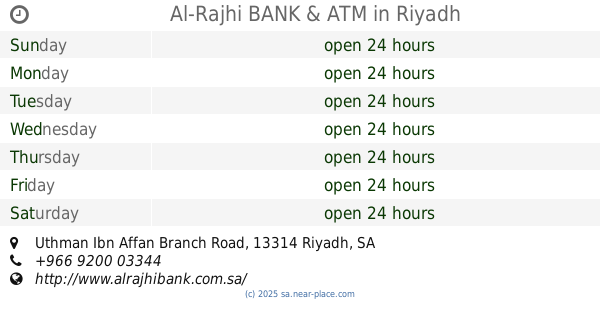
Al-Rajhi BANK & ATM
Uthman Ibn Affan Branch Road, Riyadh
Bank
read more
📑
all categories
Accounting
Administrative area level 1
Airport
Amusement park
Aquarium
Art gallery
Atm
Bakery
Bank
Bar
Beauty salon
Bicycle store
Book store
Bowling alley
Bus station
Cafe
Campground
Car dealer
Car rental
Car repair
Car wash
Casino
Cemetery
Church
City hall
Clothing store
Colloquial area
Convenience store
Country
Courthouse
Dentist
Department store
Doctor
Electrician
Electronics store
Embassy
Finance
Fire station
Florist
Food
Funeral home
Furniture store
Gas station
General contractor
Grocery or supermarket
Gym
Hair care
Hardware store
Health
Hindu Temple
Home goods store
Hospital
Insurance agency
Intersection
Jewelry store
Laundry
Lawyer
Library
Light rail station
Liquor store
Local government office
Locality
Locksmith
Lodging
Meal delivery
Meal takeaway
Mosque
Movie rental
Movie theater
Moving company
Museum
Natural feature
Neighborhood
Night club
Painter
Park
Parking
Pet store
Pharmacy
Physiotherapist
Place of worship
Plumber
Point of interest
Police
Political
Post office
Premise
Real estate agency
Restaurant
Roofing contractor
Route
Rv park, camping
School
Shoe store
Shopping mall
Spa
Stadium
Storage
Store
Sublocality
Subpremise
Subway station
Supermarket
Taxi stand
Train station
Transit station
Travel agency
University
Veterinary care
Zoo
sublocality level 1
↑