School nearby مدرسة البريد الإبتدائية (بنات)
Saudi Arabia
School nearby مدرسة البريد الإبتدائية (بنات)
مدرسة البريد الإبتدائية (بنات)
3160, Tarout Arabia Saudita
contacts phone
:
+966
Latitude:
26.5766016
, Longitude:
50.0608738
read more
nearest School
16 m
روضة البيان
Tarout
School
read more
19 m
مدرسة تاروت الابتدائية للبنات
An Nakhil
School
read more
88 m
المدرسة الابتدائية الأولى للبنات بتاروت
Tarout
School
read more
93 m
مدرسة تاروت الثانوية للبنات
An Nakhil
School
read more
100 m
الثانوية الأولى للبنات
2809, 8209, Tarout
School
read more
398 m
مركز رؤية للتعليم والإبداع
6511, Tarout
School
read more
635 m
2 Intermediate Girls
Tarout
School
read more
729 m
Council flock hands Patarrot
7885, Tarout
School
read more
789 m
Kindergarten promising steps
Tarout
School
read more
894 m
مدرسة الساحل المتوسطة بتاروت
Tarout
School
read more
909 m
مركز نفائس لرعاية الطفولة
5050, Tarout
School
read more
974 m
مدرسة سيد الشهداء الابتدائية بتاروت
Tarout
School
read more
988 m
Hassan bin Ali Primary School
Tarout
School
read more
1.15 km
مجمع الامير محمد بن فهد التعليمي البنات
3336, Tarout
School
read more
1.218 km
ملعب مدرسة الفخر الرازي
Al Qatif
School
read more
1.226 km
ملعب مدرسة أبي الدرداء
Al Qatif
School
read more
1.245 km
روضة القطيف الثانية
Anak
School
read more
1.25 km
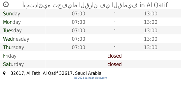
أبتدائيه تحفيظ القران في القطيف
32617, Al Qatif
School
read more
1.254 km
مدرسة تحفيظ القران الكريم الابتدائيه بالقطيف
32617, Al Qatif
School
read more
1.267 km
Fakhruddin Razi Middle School
5 (B) Street, Al Qatif
School
read more
1.271 km
Jareer Elementary School
4 (A) Street, Al Qatif
School
read more
1.274 km
مدرسة الفخر الرازي المتوسطة
4629 5ب, Al Qatif
School
read more
1.289 km
Abu Darda Elementary School
4635 بلال بن الحارث, Al Qatif
School
read more
1.298 km
حسينية الطفل الرضيع
Tarout
School
read more
1.31 km
روضة و حضانة جنة الزهراء
شارع جرير بن أوس،, Tarout
School
read more
📑
all categories
Accounting
Administrative area level 1
Airport
Amusement park
Aquarium
Art gallery
Atm
Bakery
Bank
Bar
Beauty salon
Bicycle store
Book store
Bowling alley
Bus station
Cafe
Campground
Car dealer
Car rental
Car repair
Car wash
Casino
Cemetery
Church
City hall
Clothing store
Colloquial area
Convenience store
Country
Courthouse
Dentist
Department store
Doctor
Electrician
Electronics store
Embassy
Finance
Fire station
Florist
Food
Funeral home
Furniture store
Gas station
General contractor
Grocery or supermarket
Gym
Hair care
Hardware store
Health
Hindu Temple
Home goods store
Hospital
Insurance agency
Intersection
Jewelry store
Laundry
Lawyer
Library
Light rail station
Liquor store
Local government office
Locality
Locksmith
Lodging
Meal delivery
Meal takeaway
Mosque
Movie rental
Movie theater
Moving company
Museum
Natural feature
Neighborhood
Night club
Painter
Park
Parking
Pet store
Pharmacy
Physiotherapist
Place of worship
Plumber
Point of interest
Police
Political
Post office
Premise
Real estate agency
Restaurant
Roofing contractor
Route
Rv park, camping
School
Shoe store
Shopping mall
Spa
Stadium
Storage
Store
Sublocality
Subpremise
Subway station
Supermarket
Taxi stand
Train station
Transit station
Travel agency
University
Veterinary care
Zoo
sublocality level 1
↑