Cafe nearby قهوة الطريق
Coronavirus disease (COVID-19) Situation
confirmed cases
841469
deaths
9646
Saudi Arabia
Cafe nearby قهوة الطريق
قهوة الطريق
Uhud Road, 32656, Al Qatif, SA Saudi Arabia
contacts phone
:
+966
Latitude:
26.5620609
, Longitude:
49.9712987
larger map & directions
read more
nearest Cafe
4 m
Road Café-قهوة الطريق
Uhud Rd, Ash Shahba, Al Qatif, DAMMAM
Cafe
read more
988 m
مقهى الديوانيه
Al Qatif
Cafe
read more
1.013 km
Derby Cafe
Uhud Road, Al Qatif
Cafe
read more
1.45 km
مجالس الحايك
المشتل،، القطيف
Cafe
read more
1.634 km
Andalusian cafe
طريق الظهران الجبيل السريع Dhahran Jubail Expressway, Al Qatif
Cafe
read more
1.702 km
Derby Int'l Coffee
Uhud Road, Al Qatif
Cafe
read more
1.898 km
Anamely Store
3900, Al Qatif
Cafe
read more
1.904 km
ديوانية السعيدي
Al Qatif
Cafe
read more
1.914 km
Mr. Coffee
Al Qatif
Cafe
read more
2.306 km
كوين بيكر
Unnamed Road, Al Qatif
Cafe
read more
2.328 km
استراحة النور
Al Qatif
Cafe
read more
2.378 km
Sumy Coffee
3811, Al Qatif
Cafe
read more
2.444 km
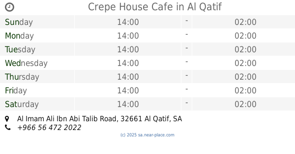
Crepe House Cafe
Al Imam Ali Ibn Abi Talib Road, Al Qatif
Cafe
read more
2.511 km
Lady's Club
Safwa
Cafe
read more
2.511 km
Lady's Club
3835, Safwa
Cafe
read more
2.512 km
نادي الصبايا lady's Club
3815, Safwa
Cafe
read more
2.512 km
نادي الصبايا
Safwa
Cafe
read more
2.716 km
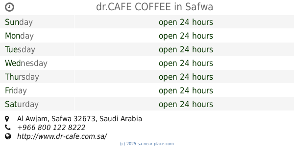
dr.CAFE COFFEE
Safwa
Cafe
read more
2.723 km
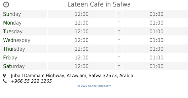
Lateen Cafe
Jubail Dammam Highway
Cafe
read more
2.775 km
Coffee Zone
Safwa
Cafe
read more
2.818 km
الصالحية كروان
Jabal Street, Al Qatif
Cafe
read more
2.883 km
مقهى ليالي الصالحية بالعوامية
2296, Al Qatif
Cafe
read more
3.013 km
Indian Food
2071 بدر, Al Qatif
Cafe
read more
3.075 km
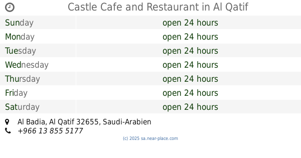
Castle Cafe and Restaurant
Al Qatif
Cafe
read more
3.089 km
مقهى قلعة القطيف
Al Qatif
Cafe
read more
📑
all categories
Accounting
Administrative area level 1
Airport
Amusement park
Aquarium
Art gallery
Atm
Bakery
Bank
Bar
Beauty salon
Bicycle store
Book store
Bowling alley
Bus station
Cafe
Campground
Car dealer
Car rental
Car repair
Car wash
Casino
Cemetery
Church
City hall
Clothing store
Colloquial area
Convenience store
Country
Courthouse
Dentist
Department store
Doctor
Electrician
Electronics store
Embassy
Finance
Fire station
Florist
Food
Funeral home
Furniture store
Gas station
General contractor
Grocery or supermarket
Gym
Hair care
Hardware store
Health
Hindu Temple
Home goods store
Hospital
Insurance agency
Intersection
Jewelry store
Laundry
Lawyer
Library
Light rail station
Liquor store
Local government office
Locality
Locksmith
Lodging
Meal delivery
Meal takeaway
Mosque
Movie rental
Movie theater
Moving company
Museum
Natural feature
Neighborhood
Night club
Painter
Park
Parking
Pet store
Pharmacy
Physiotherapist
Place of worship
Plumber
Point of interest
Police
Political
Post office
Premise
Real estate agency
Restaurant
Roofing contractor
Route
Rv park, camping
School
Shoe store
Shopping mall
Spa
Stadium
Storage
Store
Sublocality
Subpremise
Subway station
Supermarket
Taxi stand
Train station
Transit station
Travel agency
University
Veterinary care
Zoo
sublocality level 1
↑