Cafe nearby ساساز برتزل
Saudi Arabia
Cafe nearby ساساز برتزل
ساساز برتزل
7089 As Safa An Nahdah District Jeddah 23615, Al Nahdah, Jeddah 4802, Saudi Arabia
contacts phone
:
+966 53 526 2625
Latitude:
21.6249696
, Longitude:
39.1283605
larger map & directions
read more
nearest Cafe
372 m
عصيرات القصبجي
7453 الصفا،، حي النهضة،، جدة، 23615
Cafe
read more
453 m
Zanjbeel Cafeteria
As Safa, Jeddah
Cafe
read more
501 m
coffee taste لذة القهوة
7589 الصفا, An Nahdah District, Jeddah
Cafe
read more
765 m
مقهى رؤيا
Jeddah
Cafe
read more
783 m
ديوانية أبوحمد
Jeddah
Cafe
read more
817 m
ديوانية الصبا
Jeddah
Cafe
read more
858 m
مطعم مهند
Jeddah
Cafe
read more
864 m
Yogorino
Jeddah
Cafe
read more
888 m
مجمع البستان
Jeddah
Cafe
read more
919 m
Jobi
Unnamed Road, Jeddah
Cafe
read more
946 m
Kooz Karak
Jeddah
Cafe
read more
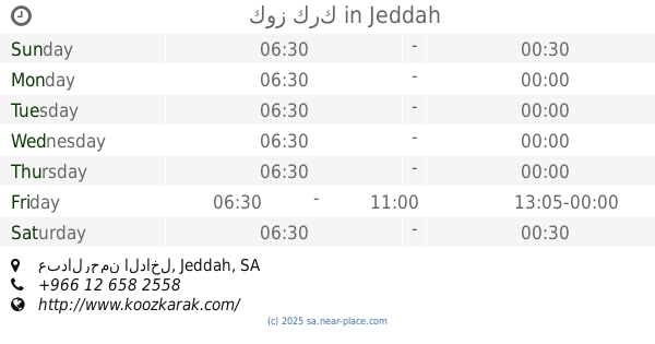
951 m
كوز كرك
عبدالرحمن الداخل, حي النهضة, Jeddah
Cafe
read more
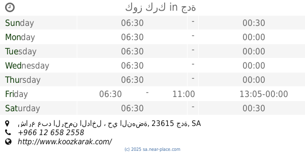
952 m
كوز كرك
شارع عبد الرحمن الداخل ، حي النهضة، جدة
Cafe
read more
1.125 km
Rose Sweets
9033 Prince Sultan Road, 2112, Jeddah
Cafe
read more
1.179 km
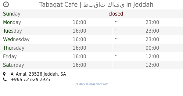
Tabaqat Cafe | طبقات كافي
Al Amal, Jeddah
Cafe
read more
1.215 km
ايسكريم المها
8623 المناهج، حي النهضة جدة 23523
Cafe
read more
1.328 km
قلنار كافية Gulnar Cafe
Jeddah
Cafe
read more
1.343 km
Starbucks Coffee
2171 لامير سلطان, جدة
Cafe
read more
1.345 km
coffee taste لذة القهوة
Jeddah
Cafe
read more
1.374 km
Takeoff Center
King Abdulaziz Road, Alnahdah, Jeddah
Cafe
read more
1.385 km
بارتي كافي
Prince Sultan Road, Jeddah
Cafe
read more
1.396 km
دارة القهوة Darat Al-Qahwa
Prince Sultan Rd Prince Sultan Road, An Naim District, Jeddah
Cafe
read more
1.403 km
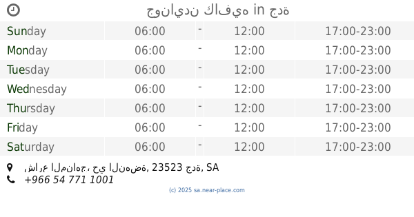
جونايدن كافيه
شارع المناهج، حي النهضة، جدة
Cafe
read more
1.409 km
Barncafe بارن كافيه
Sultan St., Jeddah
Cafe
read more
1.418 km
Barncafe بارن كافيه
AL AMIR SULTAN STREET INFRONT OF JARIR MALL BESIDE SUBWAY, AL MOHAMMEDIA, حي المحمدية - شارع الأمير سلطان, فرع سلطان 2, Jeddah
Cafe
read more
📑
all categories
Accounting
Administrative area level 1
Airport
Amusement park
Aquarium
Art gallery
Atm
Bakery
Bank
Bar
Beauty salon
Bicycle store
Book store
Bowling alley
Bus station
Cafe
Campground
Car dealer
Car rental
Car repair
Car wash
Casino
Cemetery
Church
City hall
Clothing store
Colloquial area
Convenience store
Country
Courthouse
Dentist
Department store
Doctor
Electrician
Electronics store
Embassy
Finance
Fire station
Florist
Food
Funeral home
Furniture store
Gas station
General contractor
Grocery or supermarket
Gym
Hair care
Hardware store
Health
Hindu Temple
Home goods store
Hospital
Insurance agency
Intersection
Jewelry store
Laundry
Lawyer
Library
Light rail station
Liquor store
Local government office
Locality
Locksmith
Lodging
Meal delivery
Meal takeaway
Mosque
Movie rental
Movie theater
Moving company
Museum
Natural feature
Neighborhood
Night club
Painter
Park
Parking
Pet store
Pharmacy
Physiotherapist
Place of worship
Plumber
Point of interest
Police
Political
Post office
Premise
Real estate agency
Restaurant
Roofing contractor
Route
Rv park, camping
School
Shoe store
Shopping mall
Spa
Stadium
Storage
Store
Sublocality
Subpremise
Subway station
Supermarket
Taxi stand
Train station
Transit station
Travel agency
University
Veterinary care
Zoo
sublocality level 1
↑