Cafe nearby Tabaqat Cafe | طبقات كافي
Saudi Arabia
Cafe nearby Tabaqat Cafe | طبقات كافي
Tabaqat Cafe | طبقات كافي
Al Amal, 23526, Jeddah, SA Saudi Arabia
contacts phone
:
+966 12 628 2933
Latitude:
21.6229677
, Longitude:
39.1395654
larger map & directions
read more
nearest Cafe
265 m
Rose Sweets
9033 Prince Sultan Road, 2112, Jeddah
Cafe
read more
265 m
قافلة القهوة
Al Amal, Jeddah
Cafe
read more
357 m
Yogorino
Jeddah
Cafe
read more
516 m
مطعم مهند
Jeddah
Cafe
read more
516 m
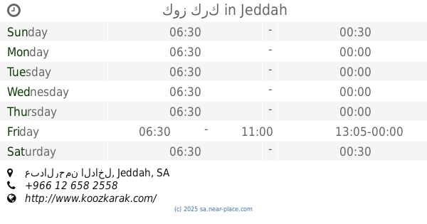
كوز كرك
عبدالرحمن الداخل, حي النهضة, Jeddah
Cafe
read more
517 m
Kooz Karak
Jeddah
Cafe
read more
525 m
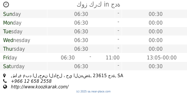
كوز كرك
شارع عبد الرحمن الداخل ، حي النهضة، جدة
Cafe
read more
529 m
House of Donuts
Jeddah
Cafe
read more
560 m
قلنار كافية Gulnar Cafe
Jeddah
Cafe
read more
569 m
Bert's
3700 احمد القرطبي, An Naim District,, Jeddah
Cafe
read more
570 m
Starbucks Coffee
2171 لامير سلطان, جدة
Cafe
read more
583 m
لاترافيات LATRAVIATA
Jeddah
Cafe
read more
588 m
JAZLI
2500 Abu Wahib Al Jashmi, An Naim District,, Jeddah
Cafe
read more
601 m
Jobi
Unnamed Road, Jeddah
Cafe
read more
625 m
تورشيللو كافيه
An Naeem Street, Jeddah
Cafe
read more
650 m
Coffee Corner
2721 شارع النعيم, حي النعيم، جدة
Cafe
read more
650 m
Coffee Corner
2721 النعيم, حي النعيم، 8839, Jeddah
Cafe
read more
659 m
بارتي كافي
Prince Sultan Road, Jeddah
Cafe
read more
962 m
ديوانية أبوحمد
Jeddah
Cafe
read more
967 m
ديوانية الصبا
Jeddah
Cafe
read more
980 m
قصر الشاي الاخضر
An Naeem Street, Jeddah
Cafe
read more
1.018 km
Bay Coffee
Jeddah
Cafe
read more
1.043 km
Beyond Coffee
Jeddah
Cafe
read more
1.078 km
ذواق القهوة
7007 حي النعيم، جدة 23622
Cafe
read more
1.179 km
ساساز برتزل
7089 As Safa An Nahdah District Jeddah 23615
Cafe
read more
📑
all categories
Accounting
Administrative area level 1
Airport
Amusement park
Aquarium
Art gallery
Atm
Bakery
Bank
Bar
Beauty salon
Bicycle store
Book store
Bowling alley
Bus station
Cafe
Campground
Car dealer
Car rental
Car repair
Car wash
Casino
Cemetery
Church
City hall
Clothing store
Colloquial area
Convenience store
Country
Courthouse
Dentist
Department store
Doctor
Electrician
Electronics store
Embassy
Finance
Fire station
Florist
Food
Funeral home
Furniture store
Gas station
General contractor
Grocery or supermarket
Gym
Hair care
Hardware store
Health
Hindu Temple
Home goods store
Hospital
Insurance agency
Intersection
Jewelry store
Laundry
Lawyer
Library
Light rail station
Liquor store
Local government office
Locality
Locksmith
Lodging
Meal delivery
Meal takeaway
Mosque
Movie rental
Movie theater
Moving company
Museum
Natural feature
Neighborhood
Night club
Painter
Park
Parking
Pet store
Pharmacy
Physiotherapist
Place of worship
Plumber
Point of interest
Police
Political
Post office
Premise
Real estate agency
Restaurant
Roofing contractor
Route
Rv park, camping
School
Shoe store
Shopping mall
Spa
Stadium
Storage
Store
Sublocality
Subpremise
Subway station
Supermarket
Taxi stand
Train station
Transit station
Travel agency
University
Veterinary care
Zoo
sublocality level 1
↑