Gas station nearby AlDrees
Saudi Arabia
Gas station nearby AlDrees
AlDrees
King Khaled Street, 32246, Dammam, SA Saudi Arabia
contacts phone
:
+966 11 235 5555
Latitude:
26.4285007
, Longitude:
50.0733833
larger map & directions
read more
nearest Gas station
6 m
ALDRESS Petrol Station
4288 الملك خالد, Dammam
Gas station
read more
426 m
Salem Alkarbi Station
King Khaled Street, Dammam
Gas station
read more
597 m
الدريس
طريق الأمير نايف بن عبدالعزيز، الجلوية، الدمام
Gas station
read more
868 m
Aldrees
Prince Nayef Bin Abdulaziz Road, Dammam
Gas station
read more
977 m
برج بن هندي
Dhahran Jubail Expressway
Gas station
read more
1.049 km
ولاء للت
شارع أبو حدرية،، الدمام
Gas station
read more
1.347 km
Sahel
Othman Ibn Affan Street, Dammam
Gas station
read more
1.412 km
Aldersses
Dammam
Gas station
read more
1.415 km
Aldrees
Dhahran Jubail Branch Road, Dammam
Gas station
read more
1.415 km
الدريس
Dhahran Jubail Branch Road, Dammam
Gas station
read more
1.42 km
Drees Dammam Station Car Auction
Dammam
Gas station
read more
1.434 km
Eruo Car
5200 Sa'ad Ibn Iyas Street, 6911, Dammam
Gas station
read more
1.449 km
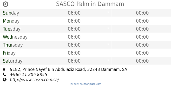
SASCO Palm
9182 Prince Nayef Bin Abdulaziz Road, Dammam
Gas station
read more
1.485 km
TOYOTA
Prince Nayef Bin Abdulaziz Road, Dammam
Gas station
read more
1.488 km
SASCO Palm
28th Street, Al Mazara St., Dammam
Gas station
read more
1.501 km
Aldrees
2601 المستشفى, Dammam
Gas station
read more
1.507 km
صيانه تويوتا
King Saud Street, Dammam
Gas station
read more
1.543 km
محطة الدريس
3193 طريق الملك فهد بن عبد العزيز, Dammam
Gas station
read more
1.561 km
AlMansoor Gas station
King Saud Street, Dammam
Gas station
read more
1.562 km
Naft
2552 King Khaled Street, Dammam
Gas station
read more
1.638 km
ENOC
2647 King Khaled Street, Dammam
Gas station
read more
1.688 km
الدريس Aldrees Gas Station
Dammam
Gas station
read more
1.763 km
jubail fm
Dammam
Gas station
read more
1.858 km
Gas Station
28th Street, Dammam
Gas station
read more
1.859 km
Sasco Gas Station
Dammam
Gas station
read more
📑
all categories
Accounting
Administrative area level 1
Airport
Amusement park
Aquarium
Art gallery
Atm
Bakery
Bank
Bar
Beauty salon
Bicycle store
Book store
Bowling alley
Bus station
Cafe
Campground
Car dealer
Car rental
Car repair
Car wash
Casino
Cemetery
Church
City hall
Clothing store
Colloquial area
Convenience store
Country
Courthouse
Dentist
Department store
Doctor
Electrician
Electronics store
Embassy
Finance
Fire station
Florist
Food
Funeral home
Furniture store
Gas station
General contractor
Grocery or supermarket
Gym
Hair care
Hardware store
Health
Hindu Temple
Home goods store
Hospital
Insurance agency
Intersection
Jewelry store
Laundry
Lawyer
Library
Light rail station
Liquor store
Local government office
Locality
Locksmith
Lodging
Meal delivery
Meal takeaway
Mosque
Movie rental
Movie theater
Moving company
Museum
Natural feature
Neighborhood
Night club
Painter
Park
Parking
Pet store
Pharmacy
Physiotherapist
Place of worship
Plumber
Point of interest
Police
Political
Post office
Premise
Real estate agency
Restaurant
Roofing contractor
Route
Rv park, camping
School
Shoe store
Shopping mall
Spa
Stadium
Storage
Store
Sublocality
Subpremise
Subway station
Supermarket
Taxi stand
Train station
Transit station
Travel agency
University
Veterinary care
Zoo
sublocality level 1
↑