Gas station nearby الدريس Aldrees Gas Station
Saudi Arabia
Gas station nearby الدريس Aldrees Gas Station
الدريس Aldrees Gas Station
Dammam Saudi Arabia
contacts phone
:
+966
Latitude:
26.4133234
, Longitude:
50.0735972
read more
nearest Gas station
244 m
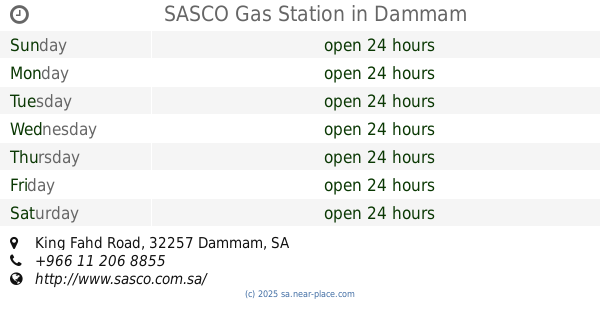
SASCO Gas Station
King Fahd Road, Dammam
Gas station
read more
515 m
Sasco Petrol Pump
Prince Nayef Bin Abdulaziz Road, Dammam
Gas station
read more
525 m
Sasco Gas Station
Dammam
Gas station
read more
640 m
ولاء للت
شارع أبو حدرية،، الدمام
Gas station
read more
689 m
محطة الدريس
3193 طريق الملك فهد بن عبد العزيز, Dammam
Gas station
read more
1.062 km
Eruo Car
5200 Sa'ad Ibn Iyas Street, 6911, Dammam
Gas station
read more
1.261 km
برج بن هندي
Dhahran Jubail Expressway
Gas station
read more
1.456 km
ENOC
8417 Umar Ibn Al Khattab, Dammam
Gas station
read more
1.456 km
إينوك
8417 Umar Ibn Al Khattab, Dammam
Gas station
read more
1.456 km
Salem Alkarbi Station
King Khaled Street, Dammam
Gas station
read more
1.541 km
محطة مزايا 1
Omar Ibn Al Khattab Street, Dammam
Gas station
read more
1.594 km
Auto Gard
Omar Ibn Al Khattab Street, Dammam
Gas station
read more
1.599 km
Alharthi Gas Station
Omar Ibn Al Khattab Street, Dammam
Gas station
read more
1.666 km
Tasheelat
King Fahd Road, Dammam
Gas station
read more
1.667 km
محطة سهل
3695 طريق الملك فهد بن عبد العزيز, Dammam
Gas station
read more
1.683 km
ALDRESS Petrol Station
4288 الملك خالد, Dammam
Gas station
read more
1.688 km
AlDrees
King Khaled Street, Dammam
Gas station
read more
1.72 km
jubail fm
Dammam
Gas station
read more
1.85 km
مغسلة الروابي للسيارات
الدمام
Gas station
read more
1.854 km
وقود
Dammam
Gas station
read more
1.862 km
Sahel
Othman Ibn Affan Street, Dammam
Gas station
read more
1.878 km
محطة مزايا1
6841 Umar Ibn Al Khattab, Dammam
Gas station
read more
1.903 km
محطة رفود للخدمات البترولية
32256, Dammam
Gas station
read more
1.905 km
Rawafed Petroleum Services
18th Street, Dammam
Gas station
read more
1.905 km
Petromin Petroleum Services
18th Street, Dammam
Gas station
read more
📑
all categories
Accounting
Administrative area level 1
Airport
Amusement park
Aquarium
Art gallery
Atm
Bakery
Bank
Bar
Beauty salon
Bicycle store
Book store
Bowling alley
Bus station
Cafe
Campground
Car dealer
Car rental
Car repair
Car wash
Casino
Cemetery
Church
City hall
Clothing store
Colloquial area
Convenience store
Country
Courthouse
Dentist
Department store
Doctor
Electrician
Electronics store
Embassy
Finance
Fire station
Florist
Food
Funeral home
Furniture store
Gas station
General contractor
Grocery or supermarket
Gym
Hair care
Hardware store
Health
Hindu Temple
Home goods store
Hospital
Insurance agency
Intersection
Jewelry store
Laundry
Lawyer
Library
Light rail station
Liquor store
Local government office
Locality
Locksmith
Lodging
Meal delivery
Meal takeaway
Mosque
Movie rental
Movie theater
Moving company
Museum
Natural feature
Neighborhood
Night club
Painter
Park
Parking
Pet store
Pharmacy
Physiotherapist
Place of worship
Plumber
Point of interest
Police
Political
Post office
Premise
Real estate agency
Restaurant
Roofing contractor
Route
Rv park, camping
School
Shoe store
Shopping mall
Spa
Stadium
Storage
Store
Sublocality
Subpremise
Subway station
Supermarket
Taxi stand
Train station
Transit station
Travel agency
University
Veterinary care
Zoo
sublocality level 1
↑