Gym nearby Kids Land
Saudi Arabia
Gym nearby Kids Land
Kids Land
Al Sayyedah Khadija Street, Jeddah Saudi Arabien
contacts phone
:
+966
Latitude:
21.5611542
, Longitude:
39.1846686
read more
nearest Gym
108 m
صالة تزلق جليد
الفيصلية،, Jeddah
Gym
read more
187 m
World Gym
Tahliya st, Serafi Mega Mall، Jeddah City
Gym
read more
694 m
Academic Spanish Football
Jeddah
Gym
read more
721 m
ملعب دانك
Abdullah Al Qasabi, Jeddah
Gym
read more
783 m
Billiar Ceaser
3481 Ahmad Ibn Al As, Al Faysaliyah District, Jeddah
Gym
read more
792 m
نادي عالم اللياقة وبناء الاجسام
2495 الامير محمد بن عبدالعزيز, حي العزيزية, Jeddah
Gym
read more
811 m
Body Action gym
Abu Hamid Al Ghazali, Jeddah
Gym
read more
814 m
Body Gym
Jeddah
Gym
read more
815 m
Body Action Gym
Jeddah
Gym
read more
893 m
Sport Village
3584 AR Rawdah, حي الفيصلية، 7374, Jeddah
Gym
read more
927 m
Dynamix Gym
Prince Mohammed Bin Abdulaziz Street, Jeddah
Gym
read more
1.043 km
مركز سهير الحديث
3487 Al Baladeah, Jeddah
Gym
read more
1.052 km
مركز القوة الرياضي
8910 Wadi Kharj, Al Aziziyah District,, Jeddah
Gym
read more
1.138 km
نادي مكينة العضلات
5140 الامير محمد بن عبدالعزيز الفرعي, حي الفيصلية،, Jeddah
Gym
read more
1.247 km
النشاط الطلابي بتعليم جدة
Jeddah
Gym
read more
1.512 km
لؤي القصاب
8100 Al Qaid, حي العزيزية،, Jeddah
Gym
read more
1.57 km
Body Masters
الروضة،, Jeddah
Gym
read more
1.599 km
ملعب الفيصلية
2657 Al Ashtar, حي الفيصلية, Jeddah
Gym
read more
1.602 km
ملعب البازوكا ( ملعب البنك )
4021 Wadi As Saad, Jeddah
Gym
read more
1.603 km
ملعب البازوكه
Jeddah
Gym
read more
1.693 km
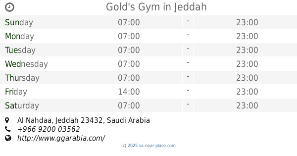
Gold's Gym
Al Nahdaa, Jeddah
Gym
read more
1.77 km
نادي باسمح(نادي خاص)
3065 Ad Daktur, حي العزيزية،, Jeddah
Gym
read more
1.77 km
Adnan Kidwai
3065 Ad Daktur, Jeddah
Gym
read more
1.776 km
Basamah Courts
Al Muwzi, Jeddah
Gym
read more
1.862 km
نادي الدباغ
2065 الامير محمد بن عبدالعزيز، حي العزيزية جدة 23342
Gym
read more
📑
all categories
Accounting
Administrative area level 1
Airport
Amusement park
Aquarium
Art gallery
Atm
Bakery
Bank
Bar
Beauty salon
Bicycle store
Book store
Bowling alley
Bus station
Cafe
Campground
Car dealer
Car rental
Car repair
Car wash
Casino
Cemetery
Church
City hall
Clothing store
Colloquial area
Convenience store
Country
Courthouse
Dentist
Department store
Doctor
Electrician
Electronics store
Embassy
Finance
Fire station
Florist
Food
Funeral home
Furniture store
Gas station
General contractor
Grocery or supermarket
Gym
Hair care
Hardware store
Health
Hindu Temple
Home goods store
Hospital
Insurance agency
Intersection
Jewelry store
Laundry
Lawyer
Library
Light rail station
Liquor store
Local government office
Locality
Locksmith
Lodging
Meal delivery
Meal takeaway
Mosque
Movie rental
Movie theater
Moving company
Museum
Natural feature
Neighborhood
Night club
Painter
Park
Parking
Pet store
Pharmacy
Physiotherapist
Place of worship
Plumber
Point of interest
Police
Political
Post office
Premise
Real estate agency
Restaurant
Roofing contractor
Route
Rv park, camping
School
Shoe store
Shopping mall
Spa
Stadium
Storage
Store
Sublocality
Subpremise
Subway station
Supermarket
Taxi stand
Train station
Transit station
Travel agency
University
Veterinary care
Zoo
sublocality level 1
↑