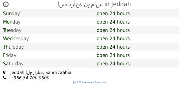
Lodging nearby استراحة لمسات
Saudi Arabia
Lodging nearby استراحة لمسات
استراحة لمسات
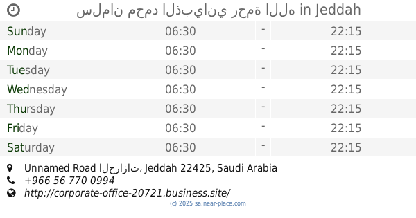
دوار المستقبل , شارع الحرازات, الحرازات، جدة Saudi Arabien
contacts phone
:
+966
Latitude:
21.4752822
, Longitude:
39.3292724
read more
nearest Lodging
295 m
استراحة جزر المالديف للمنسبات السعيدة
ابرق الرغامة، جدة
Lodging
read more
459 m
مسبح واستراحة الديوان
Jeddah
Lodging
read more
964 m
استراحة قراند لاند
Jeddah
Lodging
read more
1.238 km
استراحة الشاذلية
شارع الحرازات، جدة
Lodging
read more
1.258 km
Family Break
Jeddah
Lodging
read more
1.415 km
محمد مبارك
Unnamed Road, Jeddah
Lodging
read more
1.416 km
استراحه الجوري للمناسبات
Jeddah
Lodging
read more
1.811 km
Alfaneyah Duct Factory
Industrial Area, Phase 4, Street no.404, Jeddah
Lodging
read more
2.241 km
استراحة ريست هاوس
Unnamed Road, Jeddah
Lodging
read more
2.364 km
Break Mohammed bin aggressive Hebrew
طريق الحرازات, Jeddah
Lodging
read more
2.409 km
سلمان محمد الذبياني رحمة الله
Unnamed Road الحرازات, Jeddah
Lodging
read more
2.434 km
استراحه المنار للحتفالات
Jeddah
Lodging
read more
2.496 km
استراحة الفارس جدة الحرازات
Jeddah
Lodging
read more
2.511 km
ود للإحتفالات والمناسبات ( الشيخ / احمد الشغاغه).
Jeddah
Lodging
read more
2.543 km
منتجع الفيصل بالجبل العالي للمناسبات
Jeddah
Lodging
read more
2.561 km
Harazath M i liton
Jeddah
Lodging
read more
2.612 km
استراحة نوماس
Jeddah
Lodging
read more
2.732 km
استراحة الورود
Al Harajat، جدة
Lodging
read more
2.764 km
Waqf Furnished Apartments
Jeddah
Lodging
read more
2.797 km
الاستراحة المائية
Jeddah
Lodging
read more
2.912 km
البيت حبيب
Unnamed Road, Jeddah
Lodging
read more
3.148 km
شقة طلال روشن
Jeddah
Lodging
read more
3.328 km
Estrahat AlMalki
Jeddah
Lodging
read more
3.355 km
إستراحة الملتقى
Jeddah
Lodging
read more
3.359 km
استراحة نجمة الليل
Jeddah
Lodging
read more
📑
all categories
Accounting
Administrative area level 1
Airport
Amusement park
Aquarium
Art gallery
Atm
Bakery
Bank
Bar
Beauty salon
Bicycle store
Book store
Bowling alley
Bus station
Cafe
Campground
Car dealer
Car rental
Car repair
Car wash
Casino
Cemetery
Church
City hall
Clothing store
Colloquial area
Convenience store
Country
Courthouse
Dentist
Department store
Doctor
Electrician
Electronics store
Embassy
Finance
Fire station
Florist
Food
Funeral home
Furniture store
Gas station
General contractor
Grocery or supermarket
Gym
Hair care
Hardware store
Health
Hindu Temple
Home goods store
Hospital
Insurance agency
Intersection
Jewelry store
Laundry
Lawyer
Library
Light rail station
Liquor store
Local government office
Locality
Locksmith
Lodging
Meal delivery
Meal takeaway
Mosque
Movie rental
Movie theater
Moving company
Museum
Natural feature
Neighborhood
Night club
Painter
Park
Parking
Pet store
Pharmacy
Physiotherapist
Place of worship
Plumber
Point of interest
Police
Political
Post office
Premise
Real estate agency
Restaurant
Roofing contractor
Route
Rv park, camping
School
Shoe store
Shopping mall
Spa
Stadium
Storage
Store
Sublocality
Subpremise
Subway station
Supermarket
Taxi stand
Train station
Transit station
Travel agency
University
Veterinary care
Zoo
sublocality level 1
↑