Lodging nearby دوار التوحيد للشقق المفروشة
Saudi Arabia
Lodging nearby دوار التوحيد للشقق المفروشة
دوار التوحيد للشقق المفروشة
King Abdul Aziz Road, Jazan, SA Saudi Arabia
contacts phone
:
+966 17 323 1117
Latitude:
16.891704
, Longitude:
42.5581506
larger map & directions
read more
nearest Lodging
6 m
فندق قلب جازان
2119 Airport Road, Jazan
Lodging
read more
164 m
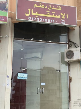
Dahtham Hotel
King Abdul Aziz Road, Jazan
Lodging
read more
358 m
Pink Flowe
7587, Jazan
Lodging
read more
371 m
شقق قصر رتيل
2377 King Abdul Aziz Road, Jazan
Lodging
read more
404 m
Alsafa Hotel
Jazan
Lodging
read more
442 m
Layali Jazan Hotel
5057 المطلع, Jazan
Lodging
read more
448 m
Al Ekhlas Real Estate
5057 المطلع, Jazan
Lodging
read more
468 m
Alandalus Hotel
Jazan
Lodging
read more
550 m
Kadi Jazan Furnished Aparthotel
Al Matla street, Al Rawda District, Jazan
Lodging
read more
564 m
Al Safa Hotel Suites
Jazan
Lodging
read more
571 m
Baisaan residential units
شارع 24 أ, Jazan
Lodging
read more
588 m
Adnan Hotel
المطلع, Jazan
Lodging
read more
591 m
شقق عدنان
Jazan
Lodging
read more
601 m
ہوٹل جزان
Prince Sultan Road, Jazan
Lodging
read more
639 m
Qasr Palace Hotel
Jazan
Lodging
read more
646 m
فندق حياة نوماس
شارع 28 أ،, Jazan
Lodging
read more
649 m
Alqasr Palace Hotel
طريق الامير سلطان بن عبد العزيز, Jazan
Lodging
read more
710 m
Kadi Jazan Hotel
8526 المطلع, Jazan
Lodging
read more
717 m
Alsalam Hotel
Airport Road, Jazan
Lodging
read more
741 m
Beauty Rayan Hotel 2
Prince Sultan Bin Abdul Aziz, Jazan
Lodging
read more
750 m
Rooz Alsalemya Hotel
Prince Sultan Bin Abdul Aziz, Jazan
Lodging
read more
764 m
Jazan quiet residential units
شارع الشيخ عبد العزيز بن باز, Jazan
Lodging
read more
830 m
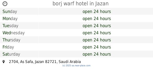
borj warf hotel
2704, Jazan
Lodging
read more
861 m
وارف
Jazan
Lodging
read more
876 m
Alhinawi Hotel
4267 Airport Road, 4414, Jazan
Lodging
read more
📑
all categories
Accounting
Administrative area level 1
Airport
Amusement park
Aquarium
Art gallery
Atm
Bakery
Bank
Bar
Beauty salon
Bicycle store
Book store
Bowling alley
Bus station
Cafe
Campground
Car dealer
Car rental
Car repair
Car wash
Casino
Cemetery
Church
City hall
Clothing store
Colloquial area
Convenience store
Country
Courthouse
Dentist
Department store
Doctor
Electrician
Electronics store
Embassy
Finance
Fire station
Florist
Food
Funeral home
Furniture store
Gas station
General contractor
Grocery or supermarket
Gym
Hair care
Hardware store
Health
Hindu Temple
Home goods store
Hospital
Insurance agency
Intersection
Jewelry store
Laundry
Lawyer
Library
Light rail station
Liquor store
Local government office
Locality
Locksmith
Lodging
Meal delivery
Meal takeaway
Mosque
Movie rental
Movie theater
Moving company
Museum
Natural feature
Neighborhood
Night club
Painter
Park
Parking
Pet store
Pharmacy
Physiotherapist
Place of worship
Plumber
Point of interest
Police
Political
Post office
Premise
Real estate agency
Restaurant
Roofing contractor
Route
Rv park, camping
School
Shoe store
Shopping mall
Spa
Stadium
Storage
Store
Sublocality
Subpremise
Subway station
Supermarket
Taxi stand
Train station
Transit station
Travel agency
University
Veterinary care
Zoo
sublocality level 1
↑