Mosque nearby Al Swailem Mosque
Saudi Arabia
Mosque nearby Al Swailem Mosque
Al Swailem Mosque
Al Bahar Al Ahmar Street, 13313, Riyadh, SA Saudi Arabia
contacts phone
:
+966
Latitude:
24.7860965
, Longitude:
46.6844112
larger map & directions
read more
nearest Mosque
226 m
Zaid ibn Thabit Mosque
Al Majdal, Riyadh
Mosque
read more
317 m
Othman Bin Afan Mosque
Riyadh
Mosque
read more
421 m
مسجد فلوة القحطاني
3013 Al Maramiyah, Riyadh
Mosque
read more
555 m
Masjid Hundt
2606, Riyadh
Mosque
read more
579 m
Al-Marzouk Mosque
An Nafal
Mosque
read more
579 m
Al-Marzouk Mosque
Riyadh
Mosque
read more
606 m
Zamil Alsalim Masjed
Wadi Bish, Riyadh
Mosque
read more
656 m
Shaykh al-Islam Ibn Taymiyyah mosque
Al Marashidah, Riyadh
Mosque
read more
694 m
Abu Bakr Mosque
Al Hanak, Riyadh
Mosque
read more
695 m
Mosque and the mother of Prince Khalid Al-Faisal
3155 سكاكا, Riyadh
Mosque
read more
796 m
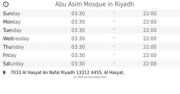
Abu Asim Mosque
7033 Al Hasyat An Nafal Riyadh 13312 4455 Al Hasyat, Riyadh
Mosque
read more
827 m
مسجد حارتنا
Riyadh
Mosque
read more
830 m
مسجد الربيعه
Riyadh
Mosque
read more
836 m
Mosque east
7781 مليلة, Riyadh
Mosque
read more
846 m
Shraideh mosque
Riyadh
Mosque
read more
849 m
جامع عبدالهادي الصفوق
Riyadh
Mosque
read more
967 m
مسجد المعجل
Al Harjah, Riyadh
Mosque
read more
988 m
Abdullah Bin Nasser Al Wahaibi Grand Mosque
Khalij Tunis, Riyadh
Mosque
read more
1.007 km
Mosque of Omar ibn al-Khattab
7471 Sada, Riyadh
Mosque
read more
1.01 km
مسجد شمال المرسلات
Riyadh
Mosque
read more
1.028 km
مسجد ذي النورين
Abdullah Ibn Sufyan, Riyadh
Mosque
read more
1.037 km
Taqwa Mosque
3501, Riyadh
Mosque
read more
1.075 km
جامع الفتح
Al Misroh, Riyadh
Mosque
read more
1.092 km
جامع العبيد
الفيض, Riyadh
Mosque
read more
1.158 km
Masjid
An Nada, Riyadh
Mosque
read more
📑
all categories
Accounting
Administrative area level 1
Airport
Amusement park
Aquarium
Art gallery
Atm
Bakery
Bank
Bar
Beauty salon
Bicycle store
Book store
Bowling alley
Bus station
Cafe
Campground
Car dealer
Car rental
Car repair
Car wash
Casino
Cemetery
Church
City hall
Clothing store
Colloquial area
Convenience store
Country
Courthouse
Dentist
Department store
Doctor
Electrician
Electronics store
Embassy
Finance
Fire station
Florist
Food
Funeral home
Furniture store
Gas station
General contractor
Grocery or supermarket
Gym
Hair care
Hardware store
Health
Hindu Temple
Home goods store
Hospital
Insurance agency
Intersection
Jewelry store
Laundry
Lawyer
Library
Light rail station
Liquor store
Local government office
Locality
Locksmith
Lodging
Meal delivery
Meal takeaway
Mosque
Movie rental
Movie theater
Moving company
Museum
Natural feature
Neighborhood
Night club
Painter
Park
Parking
Pet store
Pharmacy
Physiotherapist
Place of worship
Plumber
Point of interest
Police
Political
Post office
Premise
Real estate agency
Restaurant
Roofing contractor
Route
Rv park, camping
School
Shoe store
Shopping mall
Spa
Stadium
Storage
Store
Sublocality
Subpremise
Subway station
Supermarket
Taxi stand
Train station
Transit station
Travel agency
University
Veterinary care
Zoo
sublocality level 1
↑