Mosque nearby Shaykh al-Islam Ibn Taymiyyah mosque
Saudi Arabia
Mosque nearby Shaykh al-Islam Ibn Taymiyyah mosque
Shaykh al-Islam Ibn Taymiyyah mosque
Al Marashidah, Riyadh Saudi Arabia
contacts phone
:
+966
Latitude:
24.7866372
, Longitude:
46.6908861
read more
nearest Mosque
304 m
مسجد فلوة القحطاني
3013 Al Maramiyah, Riyadh
Mosque
read more
347 m
Shraideh mosque
Riyadh
Mosque
read more
397 m
Zamil Alsalim Masjed
Wadi Bish, Riyadh
Mosque
read more
444 m
جامع العبيد
الفيض, Riyadh
Mosque
read more
574 m
Othman Bin Afan Mosque
Riyadh
Mosque
read more
604 m
Mosque and the mother of Prince Khalid Al-Faisal
3155 سكاكا, Riyadh
Mosque
read more
653 m
Zaid ibn Thabit Mosque
Al Majdal, Riyadh
Mosque
read more
656 m
Al Swailem Mosque
Al Bahar Al Ahmar Street, Riyadh
Mosque
read more
714 m
Sheikh Abdul Wahhab Al-Esaa Mosque
Al Wadi
Mosque
read more
716 m
مسجد الشيخ عبدالوهاب العيسى
6581 Wadi As Sarh Al Wadi Riyadh 13313 3863 Wadi As Sarh, Riyadh
Mosque
read more
742 m
مسجد عبدالله الربيش رحمه الله
3944 Al Faidiyyah, Riyadh
Mosque
read more
776 m
مسجد الصالح
Al Wadi
Mosque
read more
840 m
Masjid Hundt
2606, Riyadh
Mosque
read more
858 m
جامع الفتح
Al Misroh, Riyadh
Mosque
read more
990 m
Sheikh Abdullah Almkhaddob Mosque
7993 المضاف، الوادي الرياض 13313 3487 Al Mudaf, Riyadh
Mosque
read more
996 m
مصلى المحاماة
6821 Al Qamari, Riyadh
Mosque
read more
1.057 km
Al-Marzouk Mosque
Riyadh
Mosque
read more
1.057 km
Al-Marzouk Mosque
An Nafal
Mosque
read more
1.072 km
Shalhoub mosque
Al Mudra, Riyadh
Mosque
read more
1.078 km
Alluhaidan Mosque
Northern Ring Road, Riyadh
Mosque
read more
1.084 km
Al At Taawun Mosque
3351 Thirmida, Riyadh
Mosque
read more
1.085 km
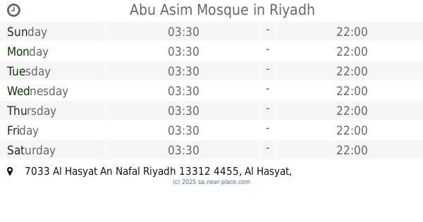
Abu Asim Mosque
7033 Al Hasyat An Nafal Riyadh 13312 4455 Al Hasyat, Riyadh
Mosque
read more
1.093 km
Prince Nawaf Bin Faisal Bin Abdal Aziz Masjid
Al Ghat, Riyadh
Mosque
read more
1.094 km
مسجد الربيعه
Riyadh
Mosque
read more
1.097 km
مسجد صالح الغفيلي
Al Kanan, Riyadh
Mosque
read more
📑
all categories
Accounting
Administrative area level 1
Airport
Amusement park
Aquarium
Art gallery
Atm
Bakery
Bank
Bar
Beauty salon
Bicycle store
Book store
Bowling alley
Bus station
Cafe
Campground
Car dealer
Car rental
Car repair
Car wash
Casino
Cemetery
Church
City hall
Clothing store
Colloquial area
Convenience store
Country
Courthouse
Dentist
Department store
Doctor
Electrician
Electronics store
Embassy
Finance
Fire station
Florist
Food
Funeral home
Furniture store
Gas station
General contractor
Grocery or supermarket
Gym
Hair care
Hardware store
Health
Hindu Temple
Home goods store
Hospital
Insurance agency
Intersection
Jewelry store
Laundry
Lawyer
Library
Light rail station
Liquor store
Local government office
Locality
Locksmith
Lodging
Meal delivery
Meal takeaway
Mosque
Movie rental
Movie theater
Moving company
Museum
Natural feature
Neighborhood
Night club
Painter
Park
Parking
Pet store
Pharmacy
Physiotherapist
Place of worship
Plumber
Point of interest
Police
Political
Post office
Premise
Real estate agency
Restaurant
Roofing contractor
Route
Rv park, camping
School
Shoe store
Shopping mall
Spa
Stadium
Storage
Store
Sublocality
Subpremise
Subway station
Supermarket
Taxi stand
Train station
Transit station
Travel agency
University
Veterinary care
Zoo
sublocality level 1
↑