Mosque nearby مسجد الياسمين
Saudi Arabia
Mosque nearby مسجد الياسمين
مسجد الياسمين
8066, الشواطي, 13321, Riyadh, SA Saudi Arabia
contacts phone
:
+966
Latitude:
24.8124025
, Longitude:
46.6305953
larger map & directions
read more
nearest Mosque
364 m
Alftymani mosque
الأصيل, Riyadh
Mosque
read more
413 m
Shaikh Mohammed Bin Abdulaziz Bin Sultan Mosque
Riyadh
Mosque
read more
461 m
Share Zouman district press mosque
2592 Jakartta, Riyadh
Mosque
read more
542 m
مسجد واحةالياسمين
6762, 3822, Riyadh
Mosque
read more
542 m
Ramadan Mosque
6777, Riyadh
Mosque
read more
618 m
Al-hargan mosque
Ar Raiyhan Valley, Riyadh
Mosque
read more
639 m
مسجد الهجرة
6549, Riyadh
Mosque
read more
676 m
Um Abdulaziz Al-Manea Mosque
6829, Riyadh
Mosque
read more
676 m
مسجد جامع ام عبدالعزيز المنيع
6829, Riyadh
Mosque
read more
697 m
مسجد
3342 الأدهم, Riyadh
Mosque
read more
750 m
مسجد الشيخ/ عبدالعزيز المطيري
2748 الضياء, 7322, Riyadh
Mosque
read more
764 m
مسجد العجاجي
3509 Al Nassefa, Riyadh
Mosque
read more
766 m
جامع الشيخ علي بن محمد الجابر
7411, Riyadh
Mosque
read more
781 m
Mousa mosque
Prince Abdullah Bin Saud Bin Abdullah Snatan Al Saud, Riyadh
Mosque
read more
828 m
مسجد الجوهرة بنت سويلم بن فوزان السويلم
Riyadh
Mosque
read more
830 m
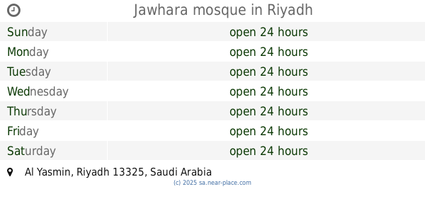
Jawhara mosque
Riyadh
Mosque
read more
844 m
مسجد ال طالب
3177 حقل, Riyadh
Mosque
read more
846 m
مسجد خالد بن الوليد رضي الله عنه
7049, 3919, Riyadh
Mosque
read more
847 m
مسجد بن طالب وامامه فهد السلامة
3177 حقل، الصحافة الرياض 13321
Mosque
read more
925 m
Prince Faisal bin Fahd Mosque
3474 Al Hawara Street, Riyadh
Mosque
read more
944 m
Almufadda Mosque
Riyadh
Mosque
read more
944 m
Almufadda Mosque
As Sahafah
Mosque
read more
962 m
مسجد ناصر محمد الوهيبي
شارع وادي الخضارم, Riyadh
Mosque
read more
963 m
Prince Faisal Bin Fahd Grand Mosque
King Fahd Branch Road, Riyadh
Mosque
read more
964 m
Masjid Saad bin Abdulrahman transplanted
Al Dawair, Riyadh
Mosque
read more
📑
all categories
Accounting
Administrative area level 1
Airport
Amusement park
Aquarium
Art gallery
Atm
Bakery
Bank
Bar
Beauty salon
Bicycle store
Book store
Bowling alley
Bus station
Cafe
Campground
Car dealer
Car rental
Car repair
Car wash
Casino
Cemetery
Church
City hall
Clothing store
Colloquial area
Convenience store
Country
Courthouse
Dentist
Department store
Doctor
Electrician
Electronics store
Embassy
Finance
Fire station
Florist
Food
Funeral home
Furniture store
Gas station
General contractor
Grocery or supermarket
Gym
Hair care
Hardware store
Health
Hindu Temple
Home goods store
Hospital
Insurance agency
Intersection
Jewelry store
Laundry
Lawyer
Library
Light rail station
Liquor store
Local government office
Locality
Locksmith
Lodging
Meal delivery
Meal takeaway
Mosque
Movie rental
Movie theater
Moving company
Museum
Natural feature
Neighborhood
Night club
Painter
Park
Parking
Pet store
Pharmacy
Physiotherapist
Place of worship
Plumber
Point of interest
Police
Political
Post office
Premise
Real estate agency
Restaurant
Roofing contractor
Route
Rv park, camping
School
Shoe store
Shopping mall
Spa
Stadium
Storage
Store
Sublocality
Subpremise
Subway station
Supermarket
Taxi stand
Train station
Transit station
Travel agency
University
Veterinary care
Zoo
sublocality level 1
↑