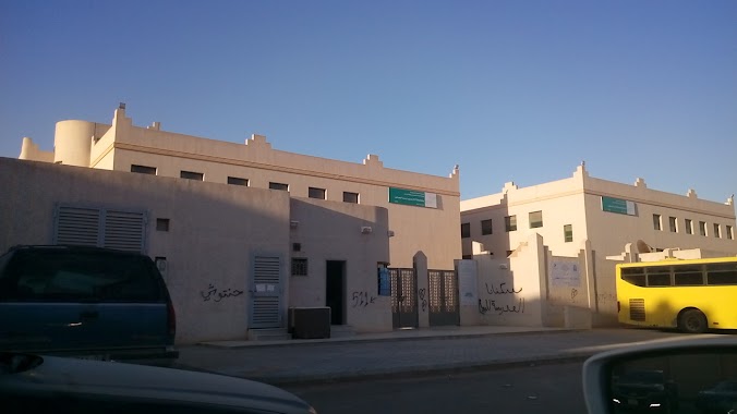
School nearby الخسف السعودية
Saudi Arabia
School nearby الخسف السعودية
الخسف السعودية
4432, Al Qadisiyah, Riyadh 13252 6955, Saudi Arabia
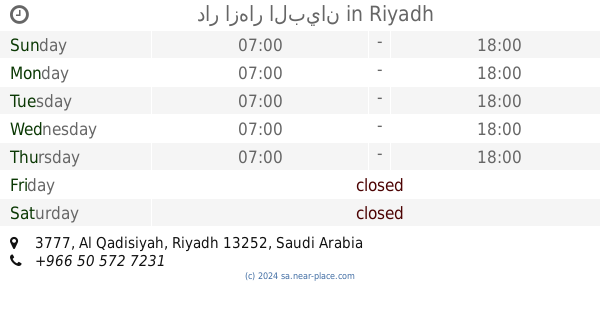
contacts phone
:
+966
Latitude:
24.8152309
, Longitude:
46.8178605
larger map & directions
read more
nearest School
472 m
مدرسة خديجة بنت خويلد
4019, Riyadh
School
read more
629 m
ابتدائية سلافة بنت سعد بنات
7296, Riyadh
School
read more
636 m
ابتدائية ثابت بن عامر
7296, Riyadh
School
read more
643 m
Fixed Ben Amer and secondary schools Aptdiah
7296, Riyadh
School
read more
664 m
متوسطة ام حبيب بنت العباس بنات
Riyadh
School
read more
668 m
Secondary Prince Fawaz bin Abdulaziz
7296, Riyadh
School
read more
673 m
دار ازهار البيان
3777, Riyadh
School
read more
747 m
مدرسة مسلم بن يسار المتوسطة
3687, 6890, Riyadh
School
read more
762 m
Elementary Khalid bin Zaid
3687, Riyadh
School
read more
783 m
متوسطة مسلم بن يسار
3687, Riyadh
School
read more
810 m
مدرسة خالد بن زيد الابتدائية بالرياض
3667, 6790, Riyadh
School
read more
951 m
متوسطة مسلم بن بسار
7005, Riyadh
School
read more
992 m
Adwaa Alriyadh Schools
Ashaikh Jaber Alahmed Alsabah, Riyadh
School
read more
1.011 km
مدرسة الامير نايف
Wadi Ad Dawasir, Riyadh
School
read more
1.103 km
متوسطة سارة بنت عبدالعزيز
Riyadh
School
read more
1.429 km
School and Kindergarten Read
3754, Riyadh
School
read more
1.429 km
مدرسة و روضة إقرأ النسائية
3754, Riyadh
School
read more
1.509 km
هائل المصلوخي
8868, Riyadh
School
read more
1.563 km
المعسكر الكشفي الدائم
8770 علي بن حمود, 4430, Riyadh
School
read more
1.649 km
مدرسة نور الهداية النسائيه
6838 الخبر, Riyadh
School
read more
1.736 km
مدرسة اجيال الدلال
6417 الوسط, Riyadh
School
read more
1.776 km
Civil School
Akli Ibn Abdulkarim, Riyadh
School
read more
1.791 km
مدرسة شهد
8256 على بن عبدالكريم، اشبيلية، الرياض 13226 4360 Akli Ibn Abdulkarim, Riyadh
School
read more
1.798 km
مدرسة البنات
الرياض
School
read more
1.804 km
الابتدائية 373
8249 Akli Ibn Abdulkarim, Riyadh
School
read more
📑
all categories
Accounting
Administrative area level 1
Airport
Amusement park
Aquarium
Art gallery
Atm
Bakery
Bank
Bar
Beauty salon
Bicycle store
Book store
Bowling alley
Bus station
Cafe
Campground
Car dealer
Car rental
Car repair
Car wash
Casino
Cemetery
Church
City hall
Clothing store
Colloquial area
Convenience store
Country
Courthouse
Dentist
Department store
Doctor
Electrician
Electronics store
Embassy
Finance
Fire station
Florist
Food
Funeral home
Furniture store
Gas station
General contractor
Grocery or supermarket
Gym
Hair care
Hardware store
Health
Hindu Temple
Home goods store
Hospital
Insurance agency
Intersection
Jewelry store
Laundry
Lawyer
Library
Light rail station
Liquor store
Local government office
Locality
Locksmith
Lodging
Meal delivery
Meal takeaway
Mosque
Movie rental
Movie theater
Moving company
Museum
Natural feature
Neighborhood
Night club
Painter
Park
Parking
Pet store
Pharmacy
Physiotherapist
Place of worship
Plumber
Point of interest
Police
Political
Post office
Premise
Real estate agency
Restaurant
Roofing contractor
Route
Rv park, camping
School
Shoe store
Shopping mall
Spa
Stadium
Storage
Store
Sublocality
Subpremise
Subway station
Supermarket
Taxi stand
Train station
Transit station
Travel agency
University
Veterinary care
Zoo
sublocality level 1
↑