School nearby Esteraha
Saudi Arabia
School nearby Esteraha
Esteraha
6718, Taibah District,, Jeddah Arabia Saudyjska
contacts phone
:
+966
Latitude:
21.7891522
, Longitude:
39.1462887
read more
nearest School
259 m
سفراء المستقبل
3915, حي طيبة،, Jeddah
School
read more
300 m
JIC GIRLS
Ibn Rasheed Al Fehri, Jeddah
School
read more
361 m
Jeddah International College Boys Campus
Jeddah
School
read more
863 m
الارض حقتنا
جدة
School
read more
939 m
مركز أجيال قادمة لضيافة الأطفال
Taibah District, Jeddah 23831
School
read more
1.012 km
دار رملة بنت ابي سفيان رضي الله عنها
3819 حي طيبة، جدة 23831 7724،
School
read more
1.012 km
دار رملة بنت ابي سيفان
3819 حي طيبة، جدة 23831 7724،
School
read more
1.199 km
مدرسة الفزاري
3507, حي طيبة،, Jeddah
School
read more
1.399 km
مركز طفلي الذكي
6935 حي طيبة جدة 23831
School
read more
1.471 km
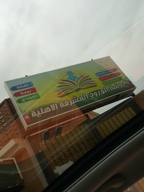
روضة الورود المشرقة الأهليه
سليمان بن جعفر, Jeddah
School
read more
1.682 km
Forum School for young civil
Wahab bin Khuwaylid, Jeddah
School
read more
2.15 km
Dar mole for the memorization of the Holy Quran
Swaied Ibn Al Samet, Jeddah
School
read more
2.236 km
ثانوية 115
3711, Al Asalah District, Jeddah
School
read more
2.242 km
الثانوية ١١٥
Jeddah
School
read more
2.281 km
مدرسة 200 الابدائية ﻷصالة
6481, حي الاصالة، 3779, Jeddah
School
read more
2.295 km
200 Elementry School
3711, حي الاصالة،, Jeddah
School
read more
2.362 km
Young Innovators
جدة
School
read more
2.363 km
مركز ضيافة الصغار المبدعون
Jeddah
School
read more
2.591 km
مدرسة الوردة البيضاء
8024, حي الفردوس, Jeddah
School
read more
2.602 km
BETA Academy
Jeddah
School
read more
2.726 km
مؤمنه
Prince Naif Road, Jeddah
School
read more
2.745 km
mohra stables
8270, Al Ferdous District, Jeddah
School
read more
2.895 km
استراحة الرابية
Jeddah
School
read more
2.979 km
روضة جيل العزم
Jeddah
School
read more
3.1 km
روضه دار الصفوة
Unnamed Road, طيبة،, Jeddah
School
read more
📑
all categories
Accounting
Administrative area level 1
Airport
Amusement park
Aquarium
Art gallery
Atm
Bakery
Bank
Bar
Beauty salon
Bicycle store
Book store
Bowling alley
Bus station
Cafe
Campground
Car dealer
Car rental
Car repair
Car wash
Casino
Cemetery
Church
City hall
Clothing store
Colloquial area
Convenience store
Country
Courthouse
Dentist
Department store
Doctor
Electrician
Electronics store
Embassy
Finance
Fire station
Florist
Food
Funeral home
Furniture store
Gas station
General contractor
Grocery or supermarket
Gym
Hair care
Hardware store
Health
Hindu Temple
Home goods store
Hospital
Insurance agency
Intersection
Jewelry store
Laundry
Lawyer
Library
Light rail station
Liquor store
Local government office
Locality
Locksmith
Lodging
Meal delivery
Meal takeaway
Mosque
Movie rental
Movie theater
Moving company
Museum
Natural feature
Neighborhood
Night club
Painter
Park
Parking
Pet store
Pharmacy
Physiotherapist
Place of worship
Plumber
Point of interest
Police
Political
Post office
Premise
Real estate agency
Restaurant
Roofing contractor
Route
Rv park, camping
School
Shoe store
Shopping mall
Spa
Stadium
Storage
Store
Sublocality
Subpremise
Subway station
Supermarket
Taxi stand
Train station
Transit station
Travel agency
University
Veterinary care
Zoo
sublocality level 1
↑