School nearby Forum School for young civil
Saudi Arabia
School nearby Forum School for young civil
Forum School for young civil
Wahab bin Khuwaylid, Jeddah Arabia Saudyjska
contacts phone
:
+966
Latitude:
21.8037099
, Longitude:
39.1507338
read more
nearest School
750 m
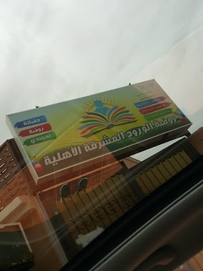
روضة الورود المشرقة الأهليه
سليمان بن جعفر, Jeddah
School
read more
768 m
دار رملة بنت ابي سيفان
3819 حي طيبة، جدة 23831 7724،
School
read more
768 m
دار رملة بنت ابي سفيان رضي الله عنها
3819 حي طيبة، جدة 23831 7724،
School
read more
929 m
مدرسة الفزاري
3507, حي طيبة،, Jeddah
School
read more
1.379 km
مركز أجيال قادمة لضيافة الأطفال
Taibah District, Jeddah 23831
School
read more
1.422 km
JIC GIRLS
Ibn Rasheed Al Fehri, Jeddah
School
read more
1.423 km
سفراء المستقبل
3915, حي طيبة،, Jeddah
School
read more
1.442 km
Jeddah International College Boys Campus
Jeddah
School
read more
1.682 km
Esteraha
6718, Taibah District,, Jeddah
School
read more
1.694 km
الارض حقتنا
جدة
School
read more
1.755 km
المدرسة ١٧٣ بنات و٢٦
Jeddah
School
read more
1.782 km
112 medium
معمر بن حارث, Jeddah
School
read more
1.796 km
Girls Schools Complex
Taiba
School
read more
1.801 km
المتوسطة الثانية عشر بعد المائة بنات ١١٢
Jeddah
School
read more
1.818 km
المدرسة الثانوية الثامنة والتسعون بنات ٩٨
Jeddah
School
read more
1.825 km
المدرسة الثالثة والسبعون بعد المائة الإبتدائية بنات ١٧٣
Jeddah
School
read more
1.838 km
Tyba MPh
Jeddah
School
read more
2.095 km
استراحة الرابية
Jeddah
School
read more
2.244 km
روضه دار الصفوة
Unnamed Road, طيبة،, Jeddah
School
read more
2.322 km
مركز طفلي الذكي
6935 حي طيبة جدة 23831
School
read more
2.433 km
الابتدائية السادسة والعشرون
Jeddah
School
read more
2.439 km
المدرسة ٢٦ الإبتدائية للبنات
Jeddah
School
read more
2.445 km
El Bashayer schools
21°48'39.7"N 39°10'23.1"E
School
read more
2.482 km
مدرسة ساره
4064, حي البشائر،, Jeddah
School
read more
2.484 km
Dar mole for the memorization of the Holy Quran
Swaied Ibn Al Samet, Jeddah
School
read more
📑
all categories
Accounting
Administrative area level 1
Airport
Amusement park
Aquarium
Art gallery
Atm
Bakery
Bank
Bar
Beauty salon
Bicycle store
Book store
Bowling alley
Bus station
Cafe
Campground
Car dealer
Car rental
Car repair
Car wash
Casino
Cemetery
Church
City hall
Clothing store
Colloquial area
Convenience store
Country
Courthouse
Dentist
Department store
Doctor
Electrician
Electronics store
Embassy
Finance
Fire station
Florist
Food
Funeral home
Furniture store
Gas station
General contractor
Grocery or supermarket
Gym
Hair care
Hardware store
Health
Hindu Temple
Home goods store
Hospital
Insurance agency
Intersection
Jewelry store
Laundry
Lawyer
Library
Light rail station
Liquor store
Local government office
Locality
Locksmith
Lodging
Meal delivery
Meal takeaway
Mosque
Movie rental
Movie theater
Moving company
Museum
Natural feature
Neighborhood
Night club
Painter
Park
Parking
Pet store
Pharmacy
Physiotherapist
Place of worship
Plumber
Point of interest
Police
Political
Post office
Premise
Real estate agency
Restaurant
Roofing contractor
Route
Rv park, camping
School
Shoe store
Shopping mall
Spa
Stadium
Storage
Store
Sublocality
Subpremise
Subway station
Supermarket
Taxi stand
Train station
Transit station
Travel agency
University
Veterinary care
Zoo
sublocality level 1
↑